Good morning. This is Doug Chabot with the Gallatin National Forest Avalanche Forecast on Thursday, December 22nd at 6:45 a.m. This information is sponsored by Yellowstone Club Community Foundation and Grizzly Outfitters. This forecast does not apply to operating ski areas.
If you are yearning for a day alone in the backcountry, today is it. Most areas are -30F, but -39F was recorded at Bridger Bowl. A W-NW wind is blowing 10-20 mph and gusting to 30 mph creating a soul-freezing wind chill of -75F! Today will warm to -15F and remain so overnight. Tomorrow’s temperatures will be a tropical +10F. Early yesterday morning a trace to 1” of snow fell. Today will be sunny and cold with W-NW wind blowing 10-20 mph.

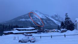
By yesterday morning 20+” (1.5” snow water equivalent, SWE) of snow fell in Cooke City. Ian caught sight of a natural avalanche billowing over the cliffs on Republic Mountain from the door of the Super 8 (photo). Dave and he rode around and saw wind moving snow and also had a collapse/whumpf under the new snow as they skied. Ian’s video explains that decision-making was easy because new snow, wind, weak layers, and a natural avalanche were a big red flag to stay out of avalanche terrain. His advice still applies today. Triggering avalanches remains likely and the danger is rated CONSIDERABLE on all slopes.

In the last 48 hours the Lionhead area and southern ranges picked up 11” of snow (.5” SWE). Last night temperatures were -28F. Wind has lessened out of the NW and active wind-loading has too. The southern mountains have weak, sugary snow (facets) under a cohesive slab (photo) that is breaking in our stability tests after thumping it with a fair bit of force (Hebgen Lake video). Thinner spots are where it’s easier to trigger slides because the weak snow is connected across a slope. Be thoughtful about getting into avalanche terrain and avoid it if there are signs of instability like collapsing or cracking. Triggering avalanches remain possible and the avalanche danger is rated MODERATE.
The northern mountains had up to 5” of new snow by daybreak yesterday. Strong wind blew that into drifts and on Tuesday a skier noticed a shallow wind-slab avalanche in Beehive Basin (observation). There is also weaker snow in the lower half of the snowpack which is showing occasional signs of weakness in our tests. In the last 7 days we’ve either been to or had observations from Divide Peak, Beehive/Bear Basins, the northern Bridger Range and Buck Creek. These all have weak, sugary facets as a common denominator. Frigid temperatures grow and weaken these crystals even more. You may not see signs of instability other than triggering a slide, so dig, test and assess the snowpack before committing to a slope. For today, triggering avalanches remains possible and the danger is rated MODERATE.
If you get out, be prepared for the unexpected. The slightest mistake or injury can be life-threatening in these arctic temperatures.
Please share avalanche, snowpack or weather observations via our website, email (mtavalanche@gmail.com), phone (406-587-6984), or Instagram (#gnfacobs).

In the last 48 hours 6” of snow has fallen. Wind is also strong and drifting snow. Weak, faceted snow is underneath thicker slabs and wind-drifting adds weight on top of the weak snow. Triggering avalanches on these slopes is likely. Stay clear of thicker drifts and tune in to signs of instability like whumpfing (collapsing) as you ride or ski, or shooting cracks, both telltale signs that you can trigger a slide.
Upcoming Avalanche Education and Events
Our education calendar is full of awareness lectures and field courses. Check it out: Events and Education Calendar.
Thursday, December 29, 6:30 p.m., Avalanche Presentation and Raffle (great odds of winning!) at MAP Brewing in Bozeman. Free.
January 4 + field day on January 7 or 8, Avalanche Fundamentals for Snowmobilers, Information and pre-registration HERE.
January 4 + field day, Avalanche Fundamentals for Skiers and Snowboarders, Information and pre-registration HERE.
Every Saturday, 10 a.m. - 2:00 p.m. Avalanche Rescue Training, drop in for any amount of time. Round Lake Warming Hut, Cooke City. Free.
Please consider donating to the Friends of GNFAC Annual Fundraiser.
Send us your observations. They do not have to be fancy, just a few sentences. Did you see any avalanches? How much new snow? Is the wind blowing and drifting snow? Pictures, snowpits and stability test scores are also welcome, but not necessary. You can help us fill in the gaps of our field work.