Snow Observations List
Toured just inside the park west of Cooke. Lots of wumphing that often propagated 20-30’ around us. Observed above 8000’. Our travel was mostly on S to E aspects.
Full Snow Observation ReportI went on a little Nordic ski up to heather lake today. Up higher the snowpack is so weak it could barely support my 150 lb body on skis, and I spent a great deal of time wallowing through two feet of facets. There was a widespread, thin layer of hoar frost throughout a good deal of the basin, mainly out in the open. I got one relatively large collapse as I stepped out in the open near heather lake, and then 5-6 smaller ones as I looped around above it.
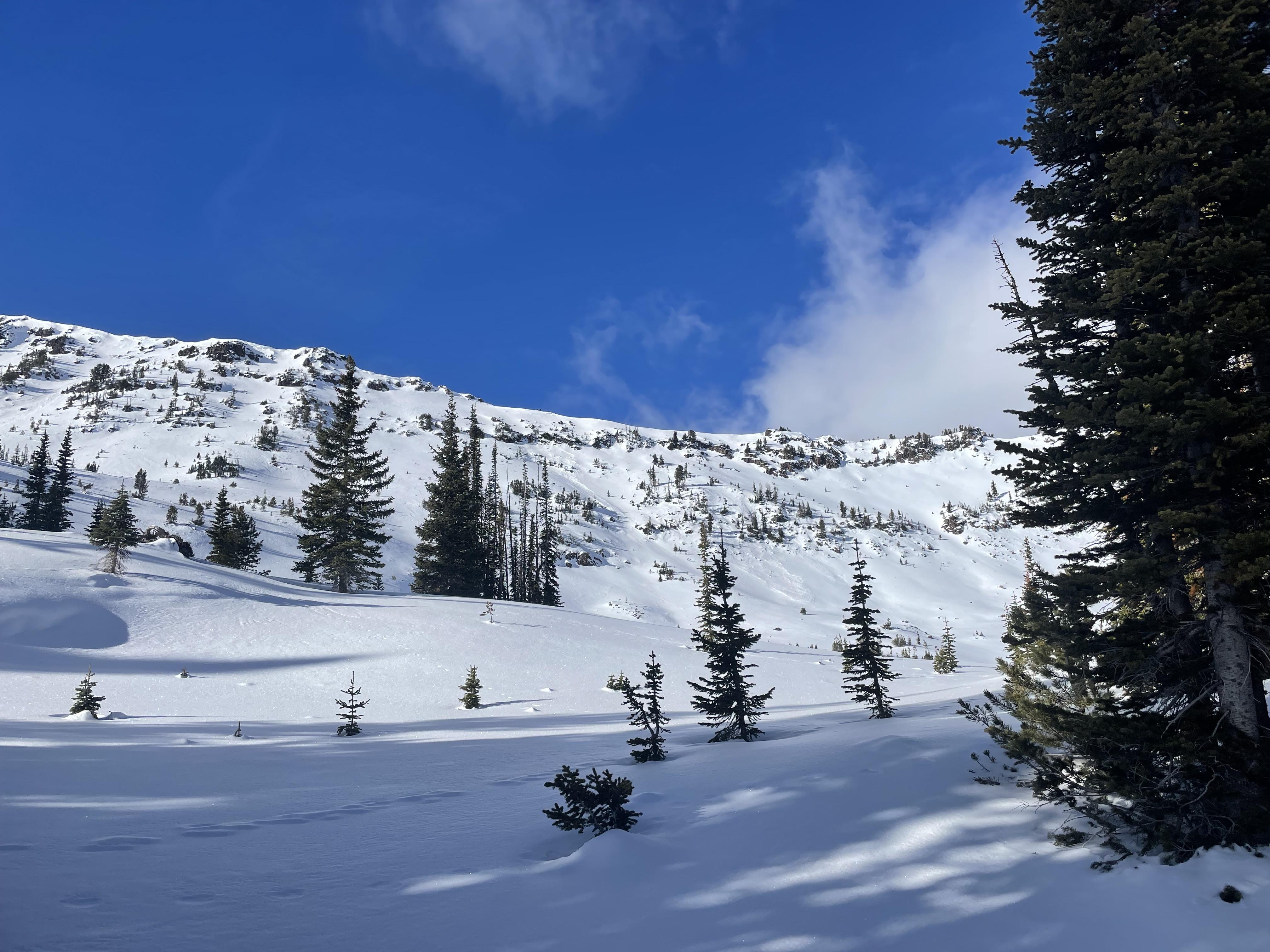
Full Snow Observation ReportSnowcover on the road is significantly worse than our last visit 10 days ago. Many bare patches on the way in and more by the time we were heading out. Overheated the sleds many times. Would recommend avoiding until it snows again. Parked at the motorized boundary and climbed and descended the east face.
There was a recent avalanche low on the east face. It appeared to have broken naturally during the downhill wind event on Monday. A 6-8" deep wind slab broke over facets approximately 100 ft wide and ran 100 vertical feet.
Climbed above the slide and dug a bit higher on of the east face (8000 ft). The slab had broken down a bit over the last week and would no longer propagate in an Extended Column Test (ECTN14 beneath the highest melt-freeze crust and ECTX on the facets lower down).
Areas that still have a substantial slab over the ubiquitous weak layers are of the most concern. Look and feel for this cohesive slab before committing to steep terrain.
Full Snow Observation Report


Rode in to put up the Taylor Fork weather station on Pika Point. Coverage on the road down low is thin, but just barely doable.
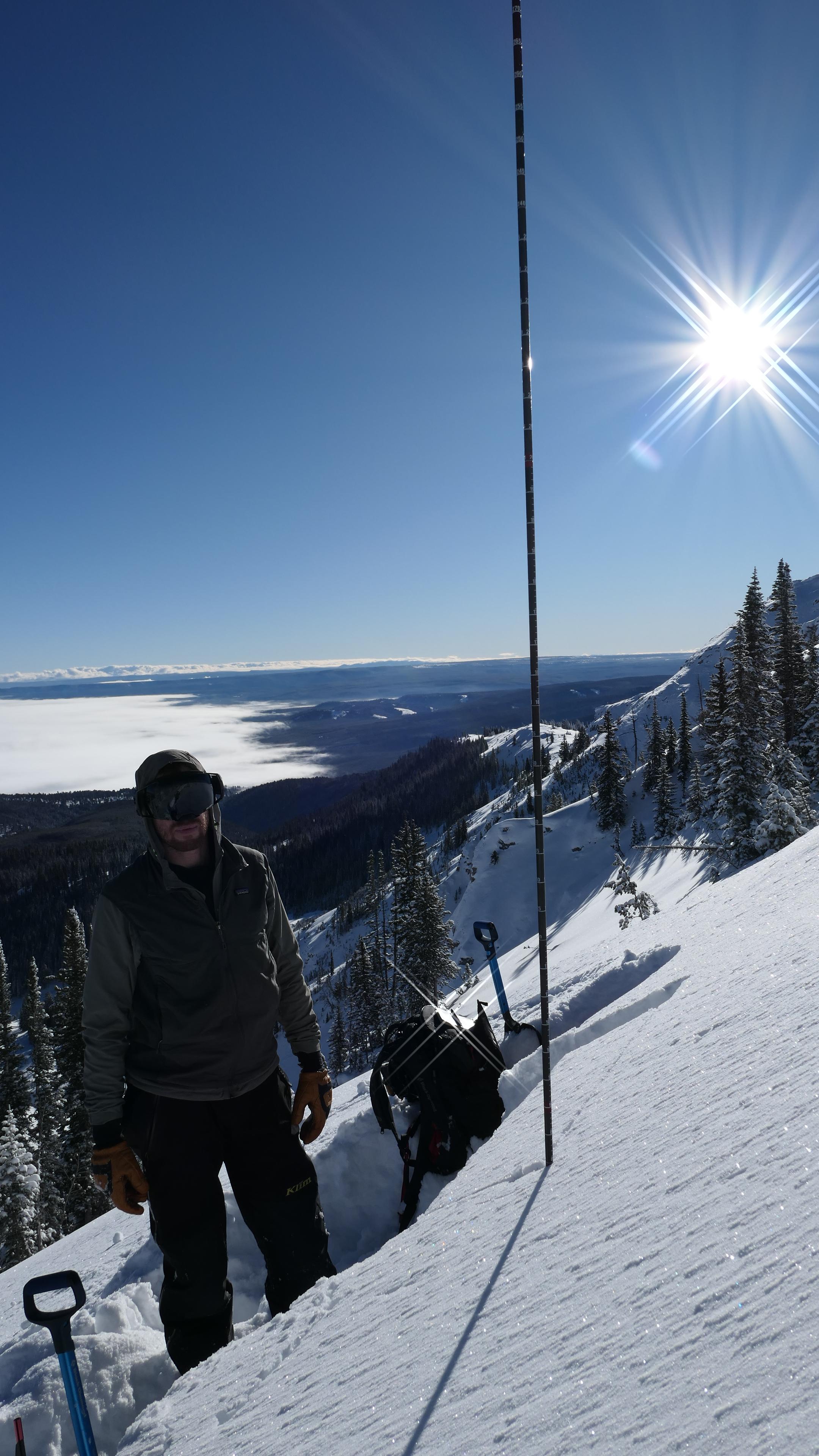
Dug a pit on an E aspect in Sunlight Basin at ~9500 ft. The entire two foot deep snowpack was weak and faceted. Even the new snow that fell last weekend is beginning to facet and surface hoar is growing on top. The slab has broken down enough that we couldn't get it propagate in an ECT (ECTN17 & ECTX) and the slab fractured in a PST (PST15/100 SF). We also dug a quick pit on the headwall in Carrot Basin and found a similarly weak ~2ft deep snowpack.
The chief concern right now would be finding a spot that does have an intact slab, most likely in a windloaded area.
Full Snow Observation Report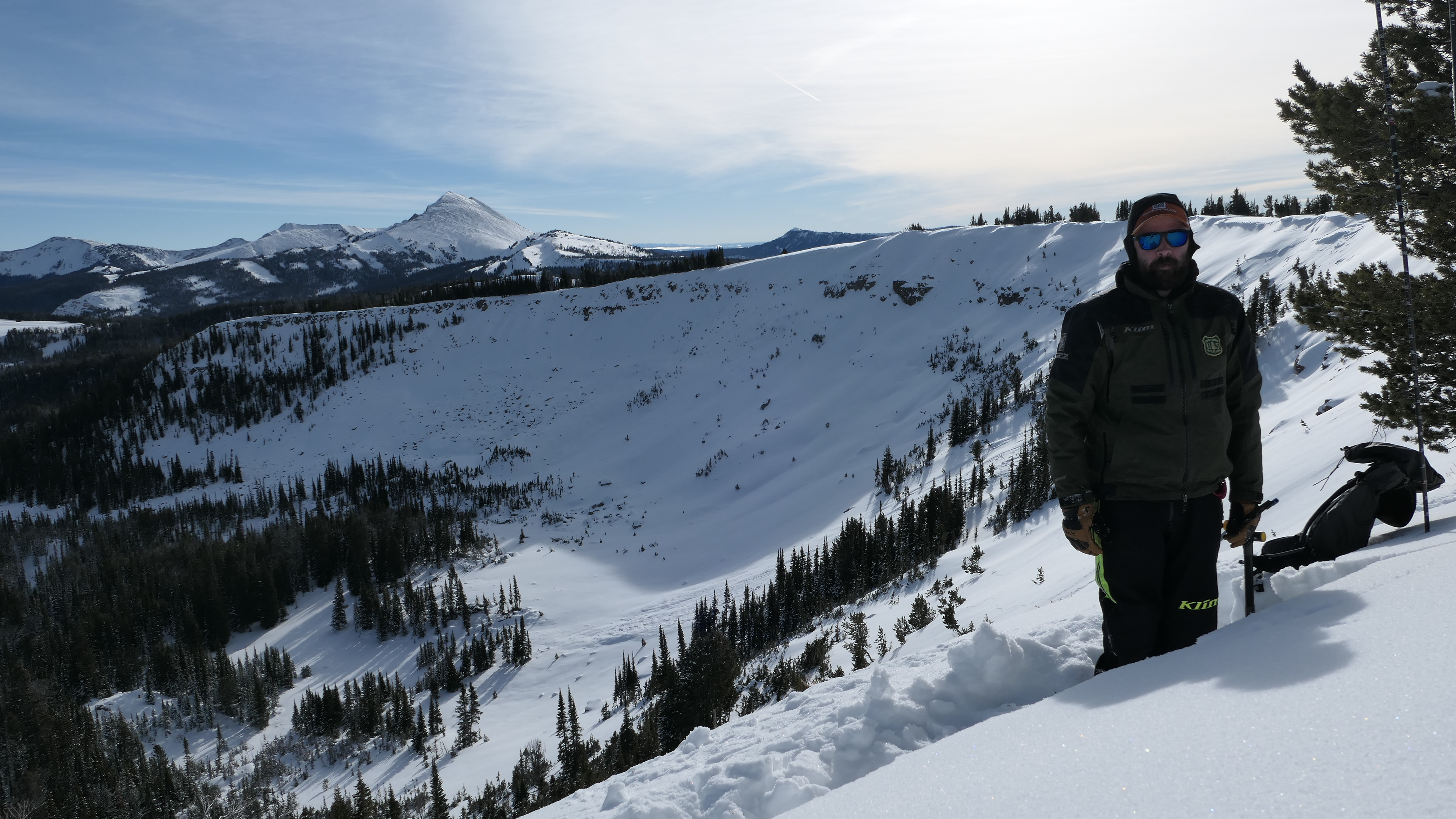


I toured up the private property line to the ridge between Beehive and Bear Basin, I skied partway down into Bear Basin from where the prayer flags used to be. I was breaking trail back up and Clyde (dog) was wallowing in the facets so I gave a big jump to try to pack in the skin track better for him and got a nice whumph, cracks shooting out about 10'. Some slopes had fresher snow forming a slab over facets, some slopes had more facets than slab, the west side going back into Beehive had a stout melt freeze crust underneath a few inches of snow. I didn't go looking for buried surface hoar so I can neither confirm or deny its existence.
Full Snow Observation ReportWe toured up Lionhead Ridge from Targhee Pass for a nice Xmas day tour. Was a calm and comfortable day. Just beyond the first large opening above 8200', I veered off the existing skin track and experienced a sizeable collapse on the NE side of the ridge. I'd estimate the collapse extended roughly 30 feet in either direction. I continued along this path and experienced one additional collapse. Fun day out. We did manage to find some supportable soft snow on the shadier side of the compass (NE to E aspect) from 8200' down to 7600' for some fun turns.
Full Snow Observation Report
Skied in Hyalite around ~8000ft on E and NE aspects. Clear skies, calm winds, beautiful day.
HS ~40cm, composed entirely of basal facets and storm snow. Was easily able to put my poles to the ground basket side down.
Despite the unconsolidated snowpack, I had 25+ significant collapses while breaking trail, with shooting cracks up to 50ft long. The collapses created visible waves on the surface of the snow and shook small trees and weeds sticking through.
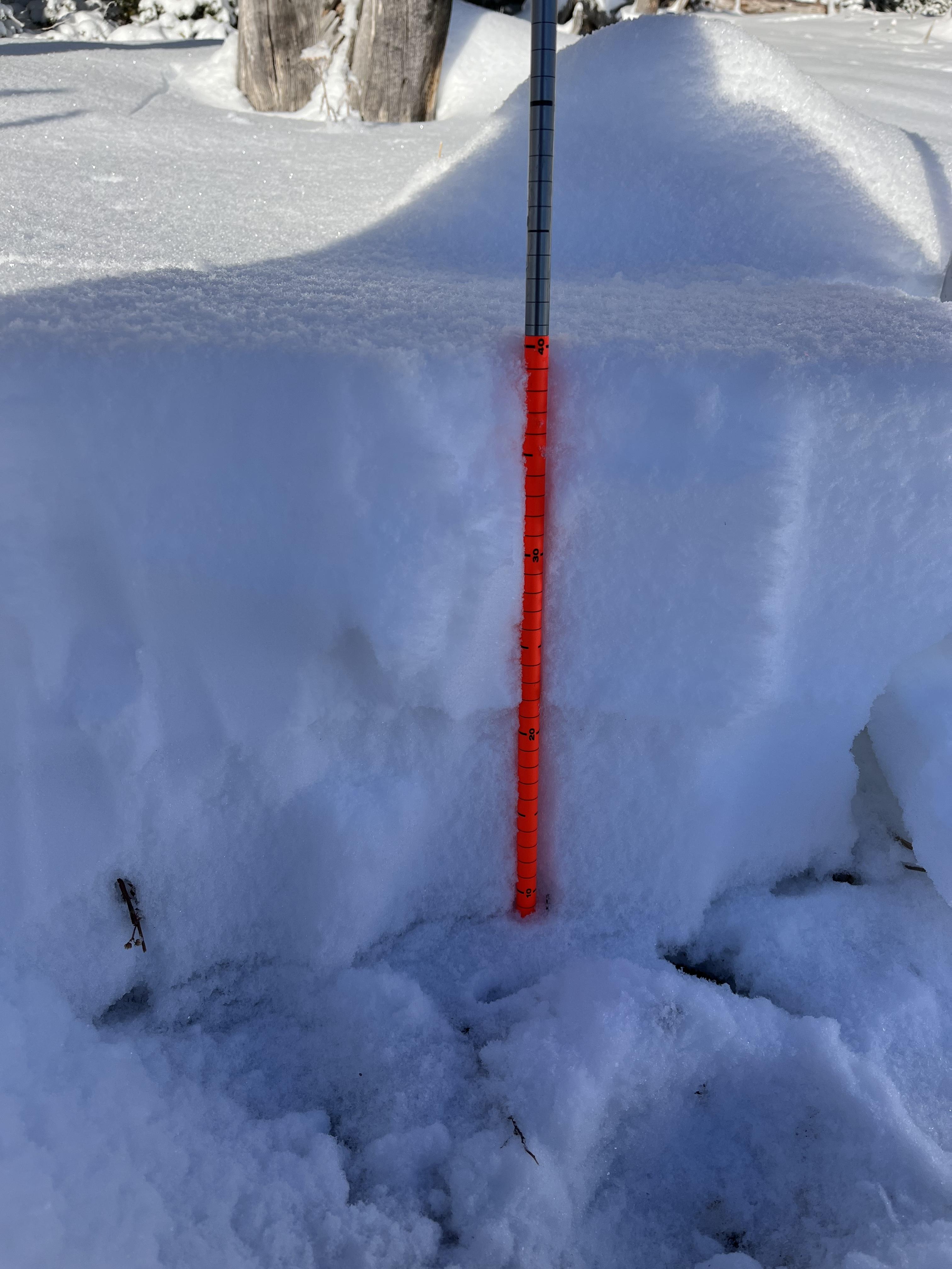
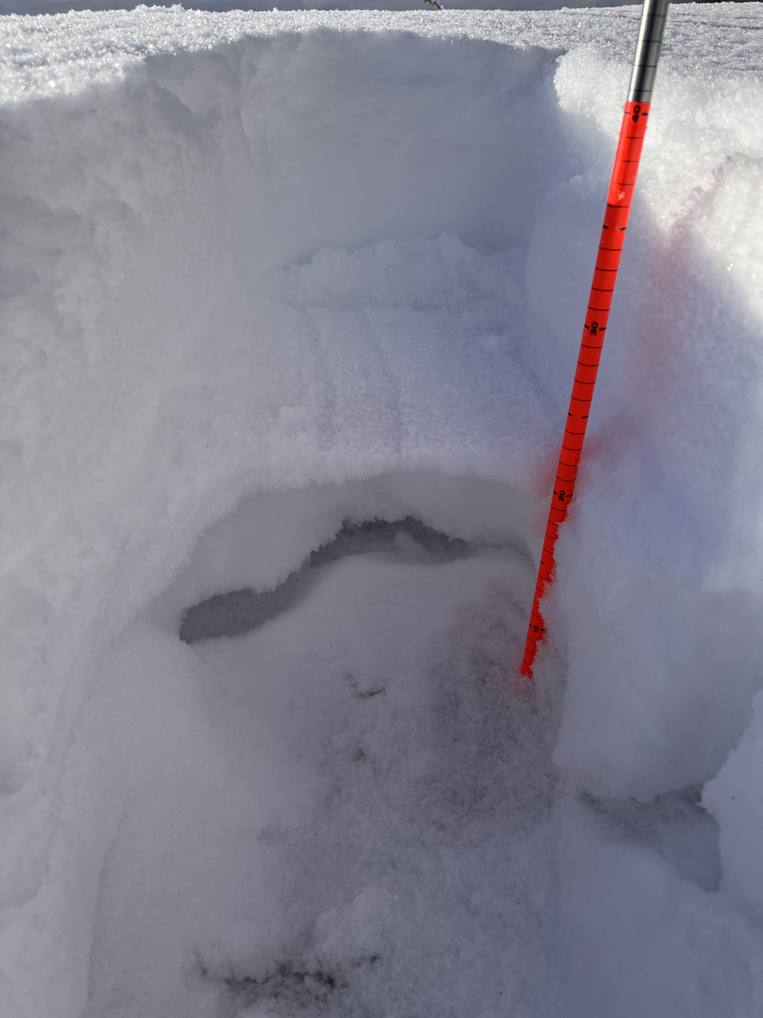
Full Snow Observation ReportWe rode to Ski Hill and dug 10-20 feet north of where it looked like an avalanche class had dug earlier this month. East aspect, 8,500'. Snow depth was 65-75 cm and we had an ECTP30 on the weakest, soft facets 20-30cm off the ground. Poor structure. We suspect this slope had been collapsed at least once from previous groups. Surface hoar was buried below the recent 6" of snow and was not reactive in tests, but pretty easy to see in the pit wall with large 1-2cm crystals above near surface facets.
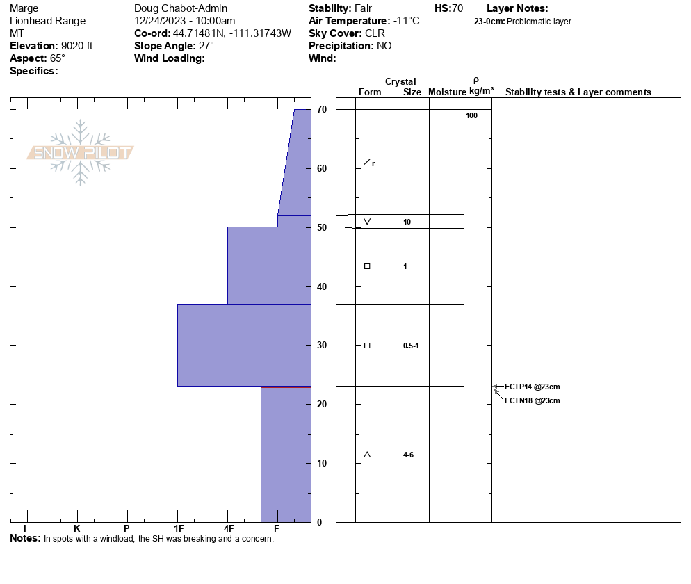
We rode further up the ridge to "Marge" and dug on an east-northeast aspect. HS was 70-85cm and we had ECTP14 on weak depth hoar/facets 30cm off the ground. Also similar findings of non-reactive surface hoar below 6-7" of recent snow. Interestingly, we also easily found surface hoar in hand pits on more wind-loaded/exposed parts of the ridge and it seemed to break more easily here. This is noteworthy because wind-loaded slopes with buried surface hoar can be a deadly combination.
Calm and sunny today with some recent drifting of the new snow, but plenty of snow to be drifted into wind slabs still.
Full Snow Observation Report

pit dug @0930 on E/SE slope. ECTN 14. Observed rollers balls as the morning progressed. put a few lines on the lower-angle meadows.
Full Snow Observation Report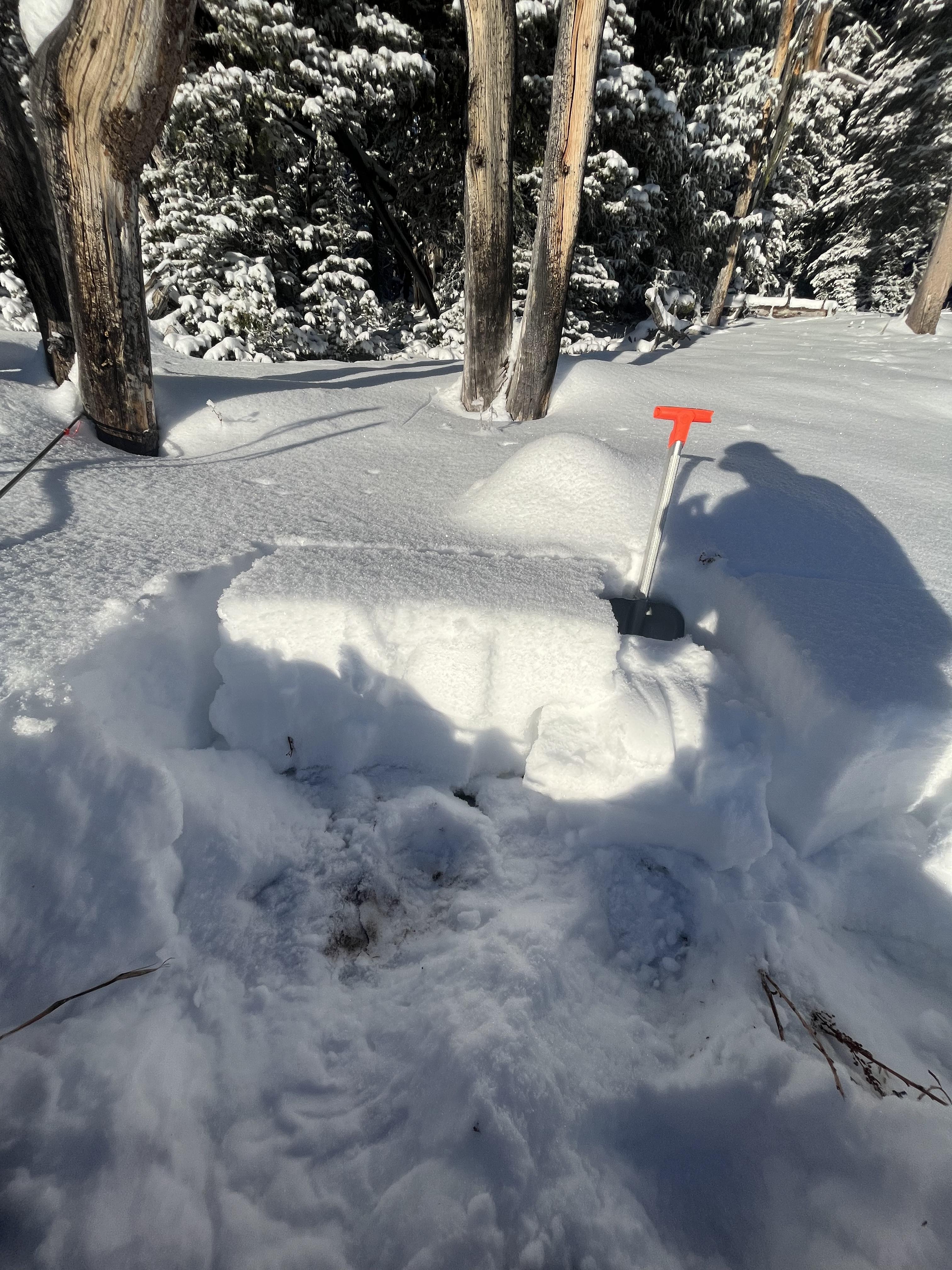
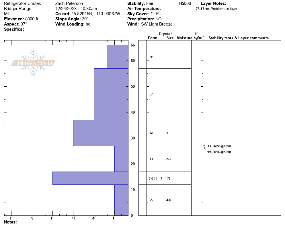
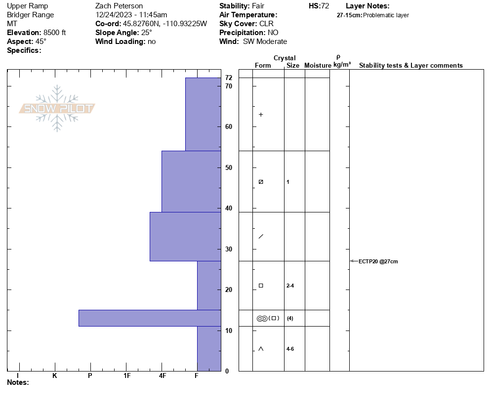
We skied north of Bridger Bowl today near the ramp. We dug at the top of the refrigerator chutes with an HS of 66 cm where 4" of new snow was on top of the existing weak snowpack. Here we had ECTN22 and ECTN16 results at the interface between early December snow and weak-faceted snow near the ground. We continued up the ramp towards the ridge where the wind was forming drifts of snow that were cracking at our ski tips. At the ridge, we were able to trigger a small avalanche on a test slope.
Below the ridge, we dug another snowpit in an area that was not wind-loaded. Here the HS was 72 cm and had 8" of new snow. The same poor structure was found here and we had an ECTP 20 result on the same interface of December snow on weak early-season snow.
While recent snow wasn't enough to dramatically increase the danger on the slope we chose to travel on doesn't mean that is the case everywhere. The snowpack structure in the Bridger Range is poor and careful assessment should be done if choosing to enter steep terrain. Slopes that have or are being loaded by wind will likely have easy-to-trigger wind slabs.
As we skied back to the ski area boundary the wind had begun to form drifts at the lower elevations that were easily triggered.

From email: "Continued, widespread collapsing today. About 10 good ones, and that was with very minimal trailbreaking/ about 700' vert.
No new avalanche activity to report today. But I did note a relatively fresh avalanche yesterday (12/22) north of Cooke. It was on a SE aspect, about 8900'. Widespread propagation there.
Widespread collapsing yesterday. Approx 20 significant collapses. Many shaking trees 50'+ away."
Full Snow Observation Report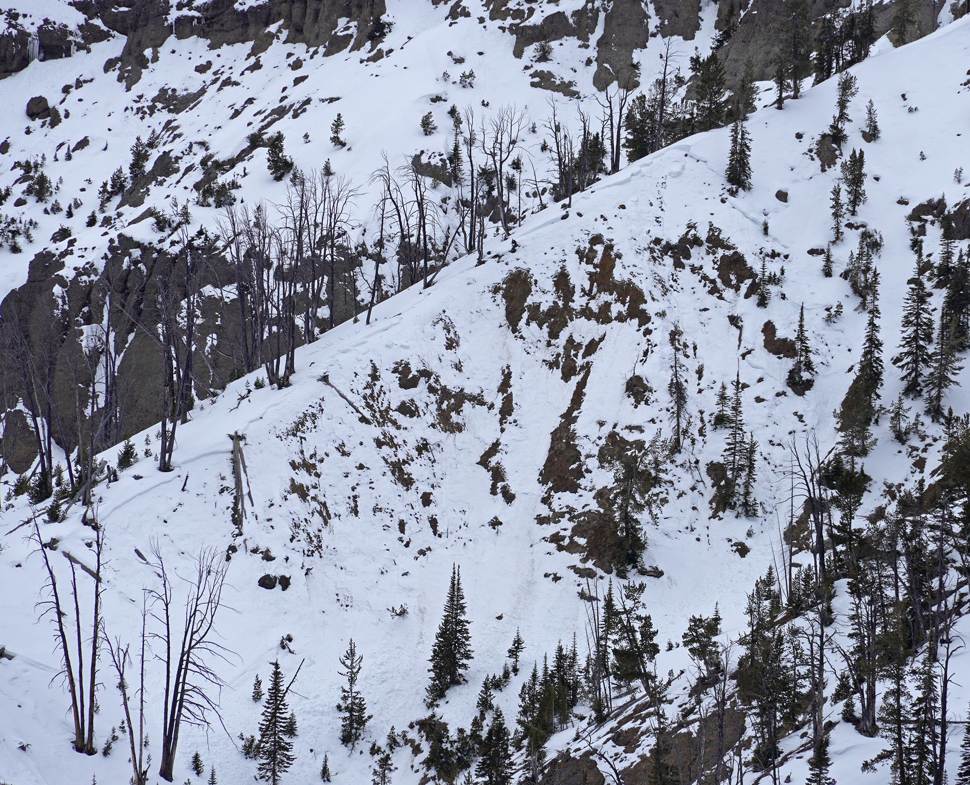
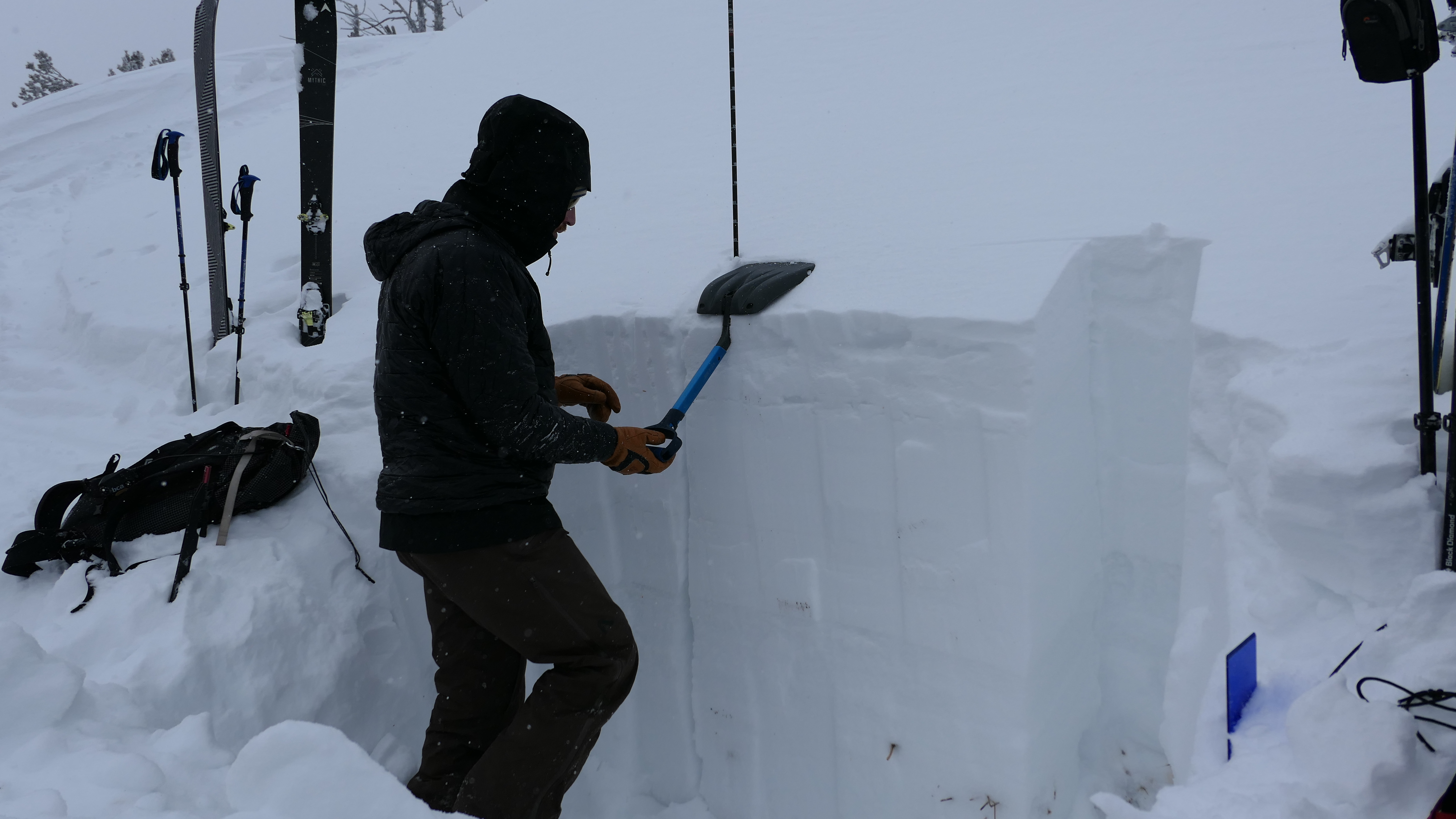
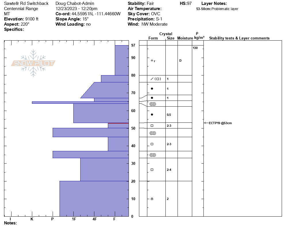
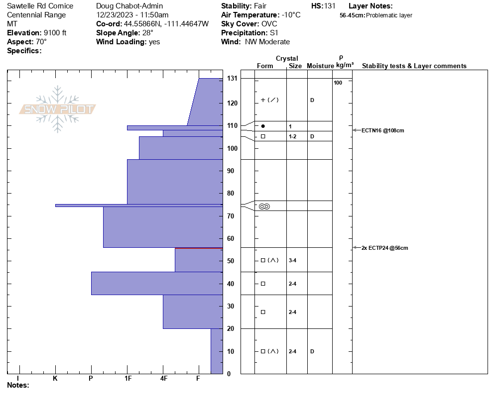
We snowmobiled up to 9,000' on Sawtelle peak, then skied to dig a couple pits. Our first pit was on an East aspect on a heavily wind loaded slope. The HS was 130cm (or 4.2 feet). There was 8" of new snow equal to 0.85" SWE, sitting over old consolidated snow that made up a slab over soft, weak facets about 50cm off the ground. We had ECTP24 x2 break on the old weak snow. Our second put was on a SW aspect and had an HS of 90cm (almost 3 feet). We got an ECTP19 here breaking on the same layer of very soft, weak facets. Wind was moderate out of the west-northwest with temps in the teens F. The new snow combined with the poor snow structure will increase avalanche danger this weekend. Video attached.
Full Snow Observation Report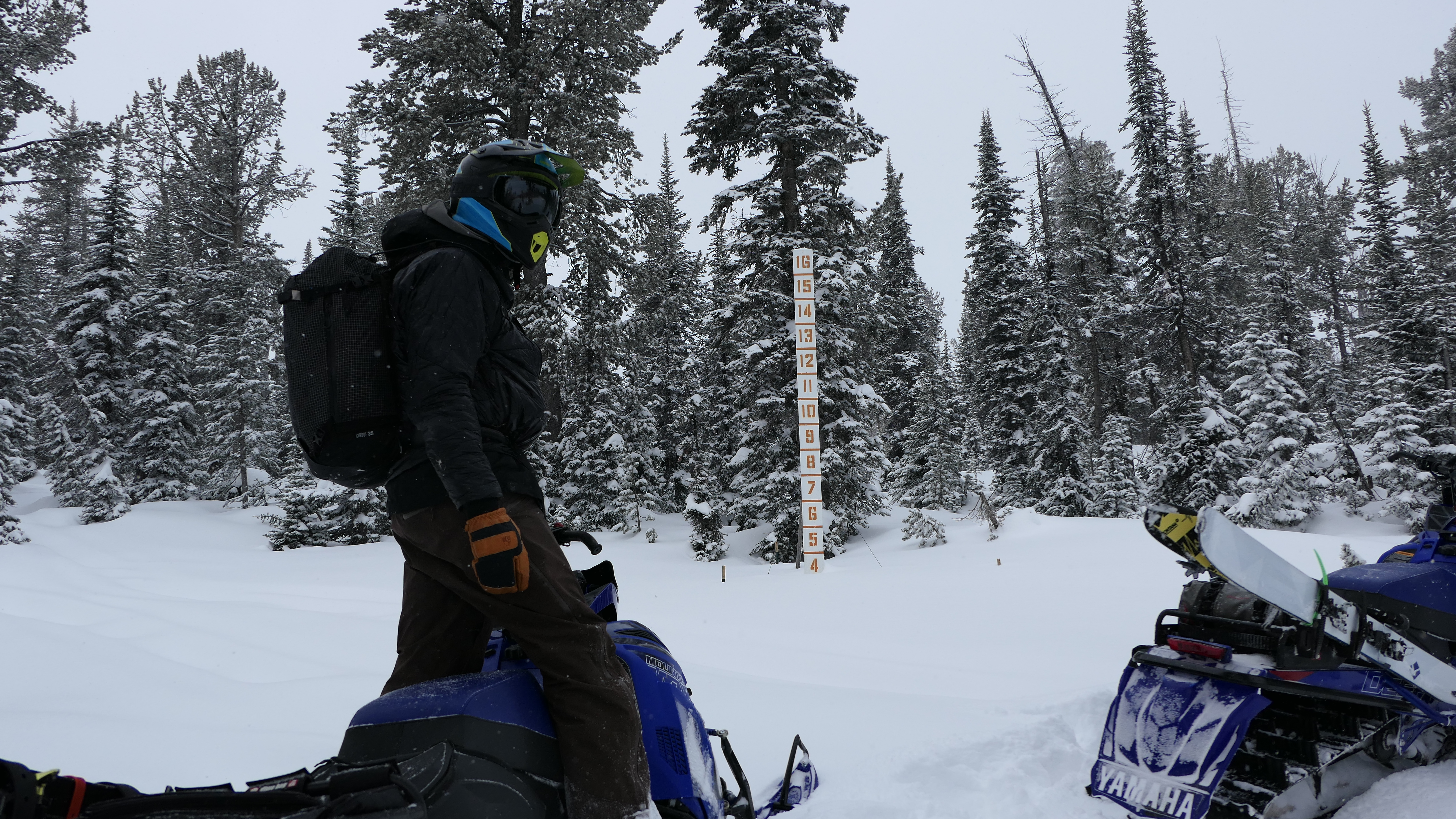

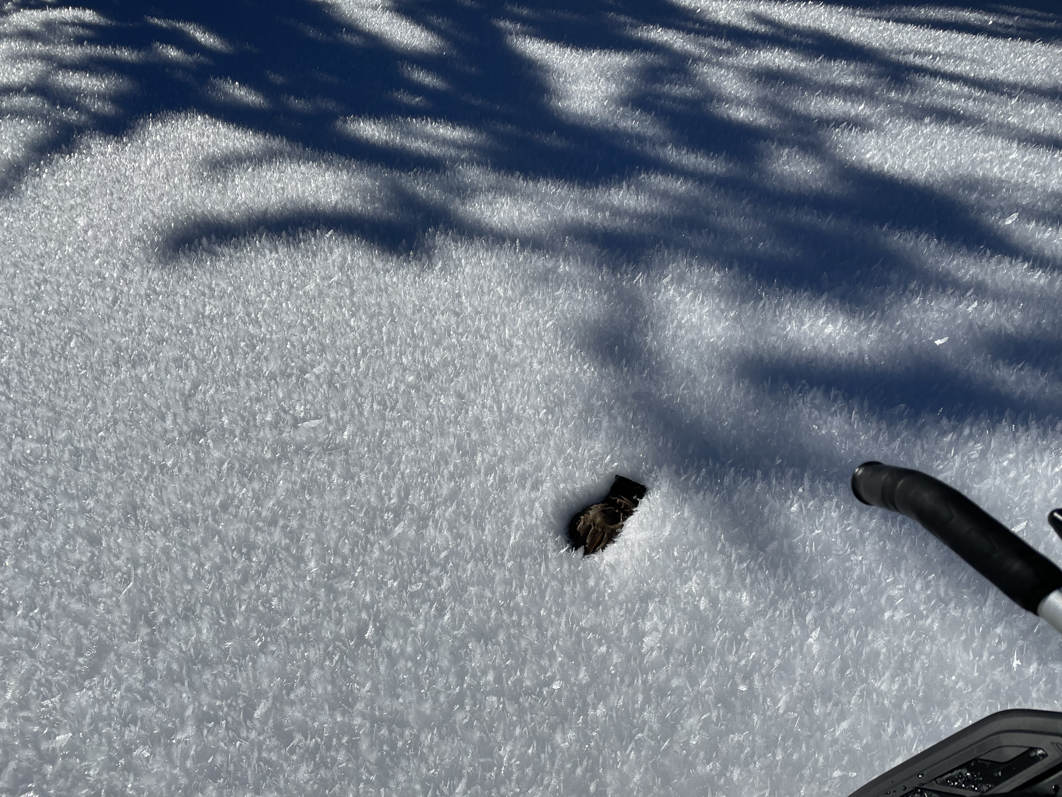
Massive surface hoar on sheltered slopes outside of West Yellowstone
Full Snow Observation Report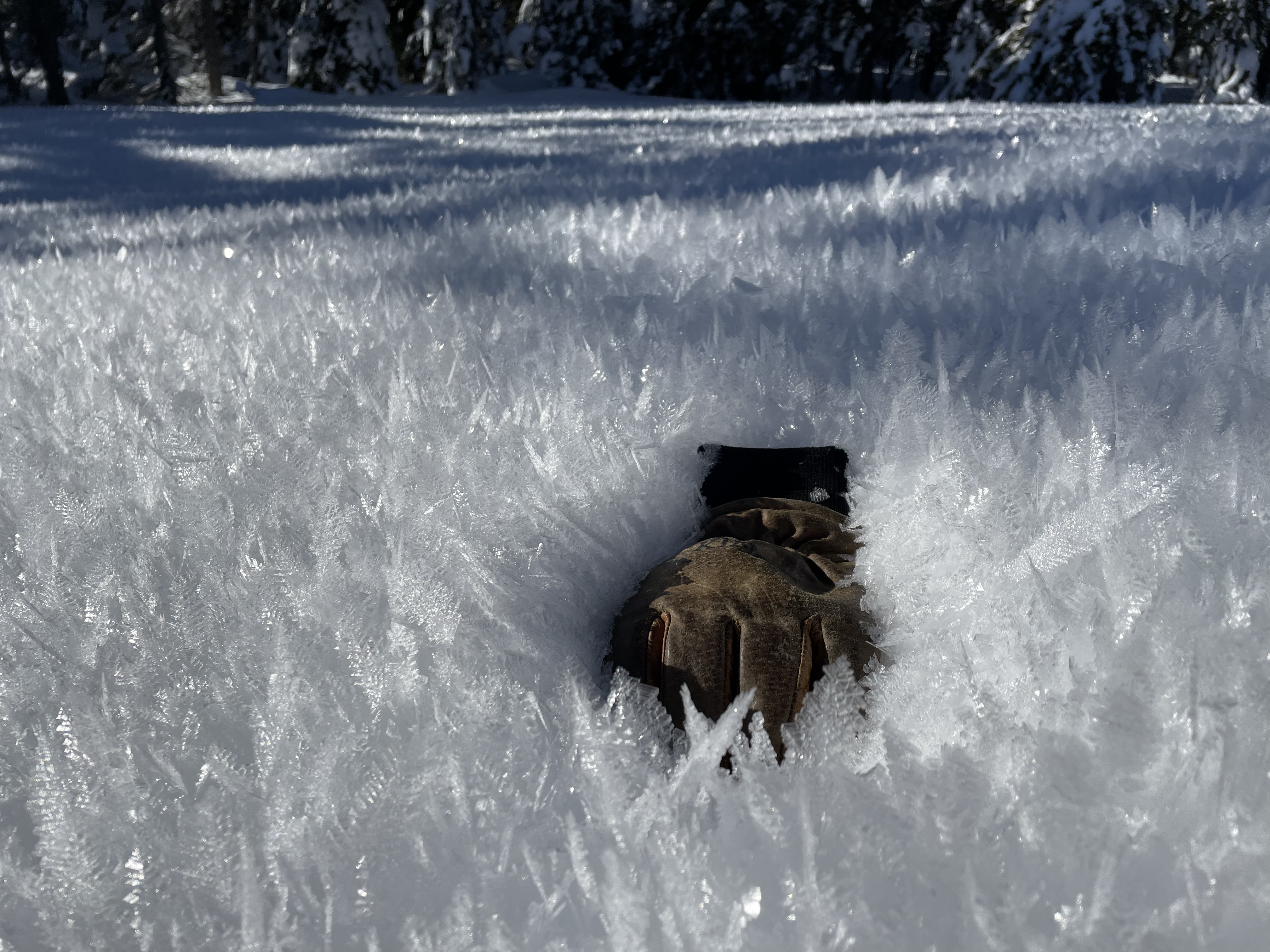
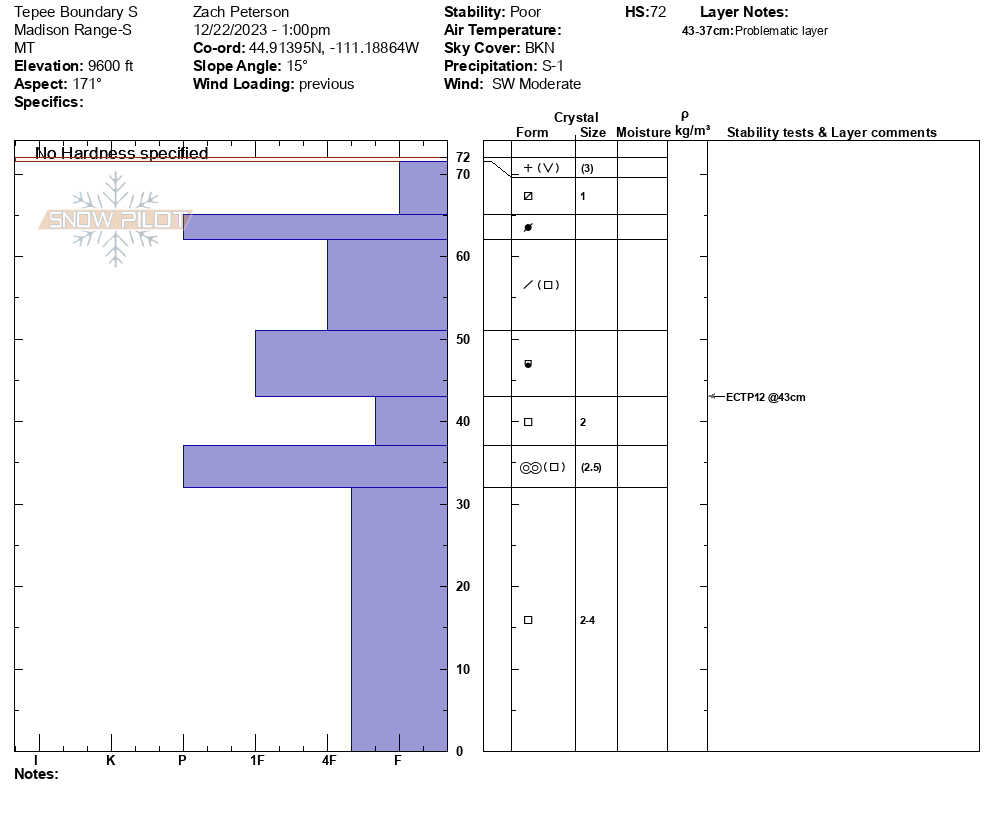
We rode onto Tepee Basin and saw little change since the last time we were there on December 13th (see that here). What we did find is that the snow has become more supportable in some areas but the poor structure remains. In our stability tests we had low scores on both northern and southern apects, with ECTP11 and ECTP12 results on facets below early December snow. The snow near the surface has begun to facet and surface hoar can be found on many slopes. In some areas this surface hoar was large and rimed.
As the snow returns areas with this poor structure will increase in danger. As the amount of snow increases so will the possibility of triggering an avalanche.
Full Snow Observation Report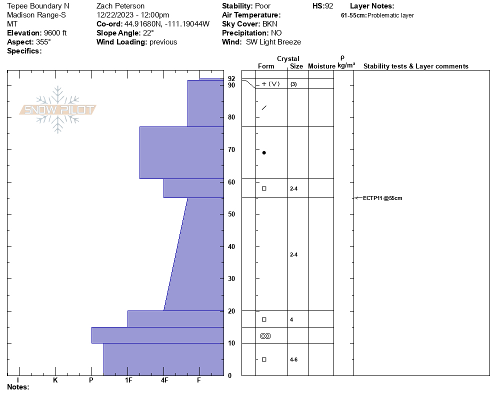

From YouTube comment 12/22/23: "I am an alpine climber - descended from Barronnette today, went south all the way down the ridgeline and descended the gully above the start of the XC trail. Heard 10+ instances of whomping and slope collapsing under my feet on both avalanche and non-avalanche slopes on N & E aspects."
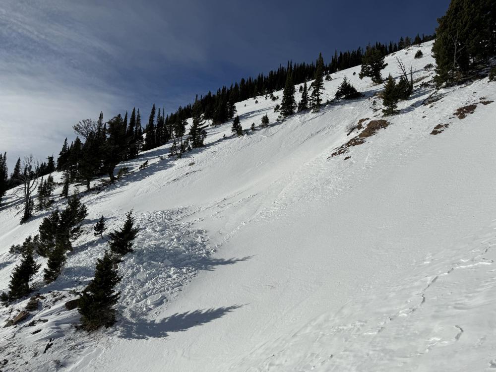
Full Snow Observation ReportPretty sure that’s an avalanche. Thought it might be goat tracks or something but you can see were some debris went through the slope below the cliff. The left side looks like it could’ve gone recently, but I couldn’t really tell.
Full Snow Observation Report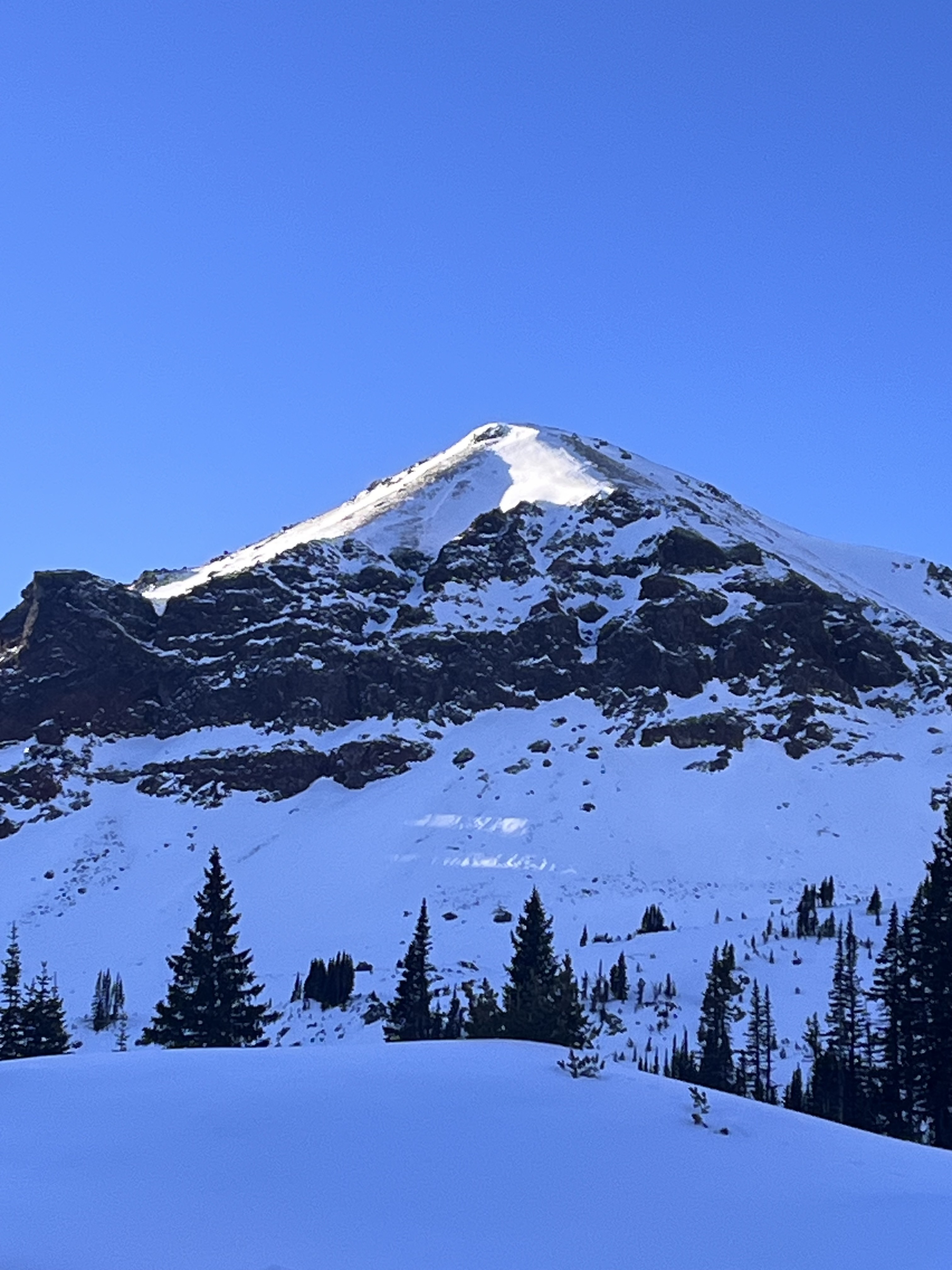
HS 55, ECTN11@33, 28 degree slope, 80 degrees E. Upper snowpack is faceting, lower snowpack is depth hoar. Surface is sun affected and has breakable melt freeze crust on all non shaded slopes. No obvious signs of instability observed.
Full Snow Observation ReportToured into Divide Basin yesterday (12/21). Saw evidence of two natural avalanches on southwest aspects (see photos). The age of these slides was hard to gauge based on our lack of recent snow. I toured to a south aspect adjacent to the south face of Divide Peak and dug a quick pit. Snow was ~65 cm deep. I did an ECT and got an ECTP3 failing on a facet layer overlaying a finger hard crust 31 cm down. Below the crust was fist hard facets to the ground.
I decided to check out some other aspects in the basin. On the majority of shady aspects I found a uniformly weak snowpack and frequently sunk in facets to above my knees while touring. On aspects with supportable snow I experienced frequent and widespread collapsing.
Full Snow Observation Report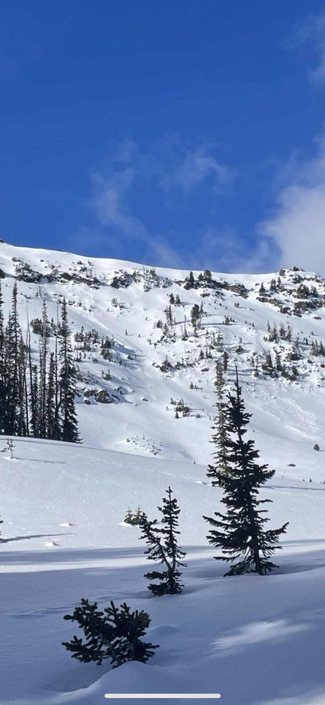
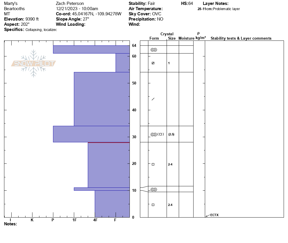
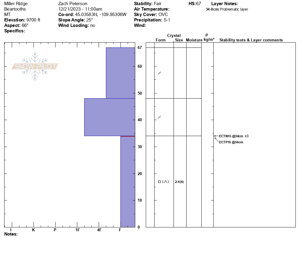
We did a large loop north of Cooke City today. Signs of instability were easy to come by but we saw more of a mixed bag of test results. We started our day near Henderson Mountain, where, while ascending, we felt a few collapses. Our first stability test had ECTX results but lacked a slab on top of the weak snow near the bottom. We stopped 100' down-slope and saw different results, ECTP15 and ECTN15 above a crust. We rode across the valley, saw a very poor snowpack structure below Miller Ridge, and got varied results (ECTP15, ECTN15 x 3). Regardless of test scores, I have difficulty trusting such a weak snowpack structure.
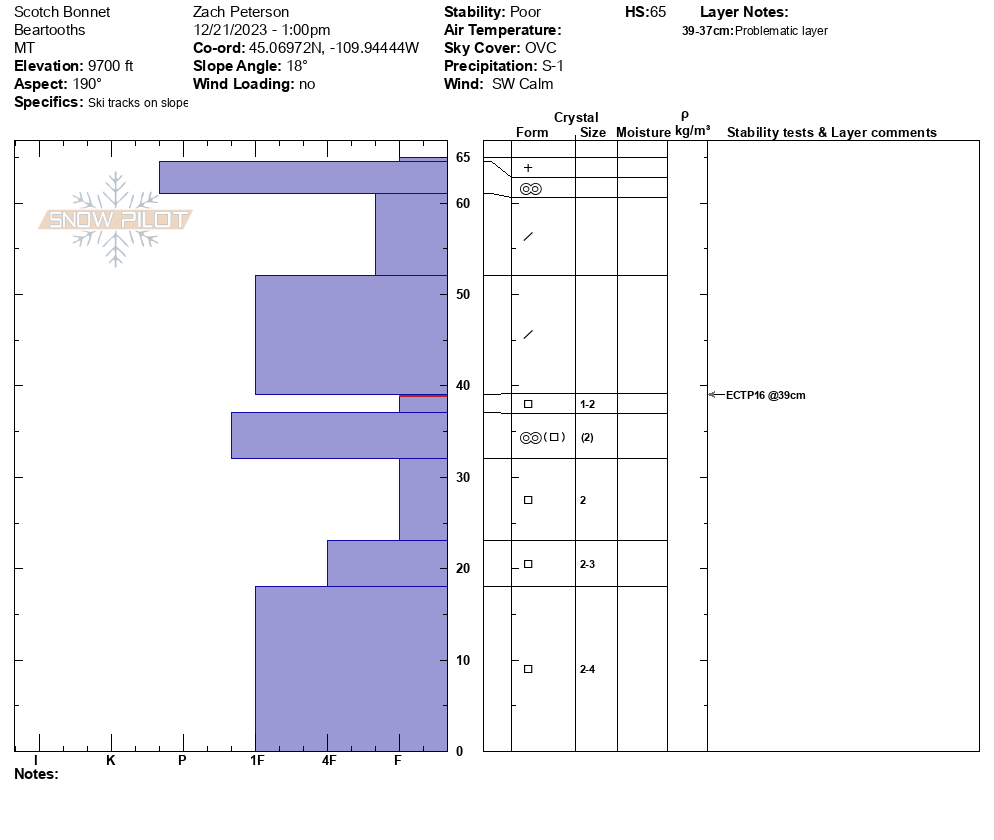
Finally, we rode back to Scotch Bonnet to see how things had changed since Sunday when Alex was there. The poor structure Alex saw on Sunday was still there, with continued unstable test results (ECTP16 on weak snow above a crust).
My partner and I felt better about the conditions today than yesterday at Woody Ridge. The weak structure around Cooke City is widespread. Safe travel requires careful snowpack evaluation, cautious route finding, and conservative decision-making.
Full Snow Observation Report