Advisory Archive
Over the past 24 hours a ridge of high pressure has kept conditions dry with seasonal temperatures. At 4 am this morning mountain temperatures are ranging from the mid teens to low 20s F with Madison Plateau near West Yellowstone being the cold spot at 1⁰ F. Winds are out of the WSW at 5-15 mph. Today temperatures will reach the mid 20s to low 30s F and winds will blow out of the WSW at 10-20 mph. Skies will become partly cloudy by this afternoon as the ridge begins to flatten.


No snow fell since yesterday and skies were clear overnight. Temperatures this morning were near 10 degrees F and westerly winds were blowing 15-30 mph. In some places they blew from the SW while in other places they blew from the NW. Today will have clear skies and sunshine. Temperatures should reach the mid 20s F and winds should continue blowing westerly at 15-30 mph.
Most places remained dry or received a trace of snow overnight except the mountains near Cooke City where 1 inch of new snow fell. This morning temperatures were in the low teens F and winds were blowing 10-15 mph with gusts of 20-30 mph mostly from the NW. Skies will clear today as drier air moves over SW Montana. Temperatures should warm into the low 20’s F and winds will remain unchanged. The forecast appears to be dry though the weekend, with great weather for the Ice Festival in Hyalite Canyon.


Since our last forecast on Monday morning no new snow has fallen in southwest Montana. Mountain temperatures were near or below zero early in the week, but have warmed substantially. This morning they read in the low 20s around Bozeman, in the teens near Big Sky and the single digits in West Yellowstone and Cooke City. Winds have been westerly at 15-30 mph. A small disturbance will drop in from Canada tonight. The winds will shift to the northwest as temperatures drop into the single digits with a trace to one inch of snow falling. It’s not very exciting and I’m unhappy to report that dry weather is forecasted through the weekend.
A ridge of high pressure sitting over the Pacific Northwest is producing a northerly flow over the region. As a result, cold-clear conditions exist over southwest Montana. Currently mountain temperatures are ranging from 5-15 below zero and winds are light out of NNW at 5-15 mph. Today, temperatures will hike into the low teens and winds will continue to blow out of the NNW at 5-15 mph. Dry and warmer conditions will remain over southwest Montana through Tuesday.
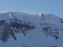
Wednesday’s storm favored the northern Gallatin and Madison ranges. By yesterday morning, 9 inches of snow fell at Big Sky and Hyalite Canyon, 5-8 inches fell near Cooke City, and 2-3 inches fell in all other areas. Since then no more has snow fallen. Winds blew strong from the NW yesterday afternoon at 15-30 mph and shifted to the SW this morning. Winds were calmer near Cooke City and West Yellowstone this morning blowing 5-15 mph. Mountain temperatures at 4 a.m. were in the mid to high teens F although valley temperatures near West Yellowstone were -10 degrees F.
Today a cold front will move over the area bringing light snow and colder temperatures. Winds will blow 20-30 from the W ahead of this front then calm and shift to the N as this front passes. Temperatures should drop into the single digits F by this afternoon. By this evening 1-3 inches of snow should accumulate.


Over the last few days mountain temperatures have been warmer than average and reached into mid to high 30s as westerly winds blew 10-25 mph. Always ahead of the curve, Cooke City got two inches of snow last night. This afternoon will be stormy and remind us that winter has not forsaken us. Arriving from the northwest, a cold front will produce snow in the mountains. By late tonight I’m expecting six to eight inches of new snow with temperatures dropping into the single digits to low teens. Winds will increase from the northwest today with gusts reaching 40-50 mph tonight. Tomorrow looks to be cold and partly cloudy.
A developing cold front has replaced yesterday’s warm-sunny weather with cloudy skies and slightly cooler temperatures. Currently mountain temperatures are ranging from the mid 20s to low 30s and winds are out of the WSW at 15-30 mph. As the cold front moves through the region this morning, we can expect a chance of mountain snow and valley rain with accumulations of one inch possible in the higher elevations. A ridge of high pressure will build behind the cold front producing partly cloudy skies and drier conditions by this afternoon. Highs today will be in the mid 20s to low 30s in the mountains and winds will stay out of the WSW at 15-30 mph.
A strong cold front pushed through southwest Montana yesterday afternoon producing strong winds and isolated snow showers. Most areas picked up 2-4 inches with the exception of the Bridger Range that received a trace to one inch. Winds were blowing 50-60 mph out of the WNW with the arrival of the frontal passage.
Currently, mountain temperatures are ranging from 5-10⁰ above zero and winds are blowing 10-20 mph out of the WNW. A ridge of high pressure will continue to build over the region today producing clear skies and warmer temperatures. Highs today will climb into the upper 20s to low 30s and winds will stay out of the WNW at 10-20 mph. Mostly sunny skies and warmer temperatures will remain over the area through Sunday.


At 4 a.m. ridgetop winds were blowing 20-30 mph mostly from the S and temperatures were in the 20s F. This morning as a cold front approaches, winds will increase and blow 20-40 mph from the W. Temperatures should drop throughout the day into the teens F and colder by tonight. Snowfall will begin sometime this morning and end this evening. The mountains near West Yellowstone and Cooke City should get 2-4 inches and the mountains near Bozeman and Big Sky should get 1-3 inches. Warmer and drier weather will move back over the area for the weekend.