Good Morning. This is Eric Knoff with the Gallatin National Forest Avalanche Forecast issued on Saturday, December 15th at 7:00 a.m. Today’s forecast is sponsored by Yellowstone Ski Tours and Montana State Parks. This forecast does not apply to operating ski areas.
Overnight the mountains near Cooke City picked up 1-2” of new snow. No new accumulation is expected today. This morning, temps are in the 20’s F and winds are blowing 20-50 mph out of the west-southwest with gusts around Big Sky breaking 60 mph. Warm and windy conditions will continue through the day. Highs climb into the upper 20’s to low 30’s F and winds remain strong out of the west-southwest. No new snow is expected through the weekend.

The snowpack situation in Lionhead is different than all other areas. A persistent weak layer of sugary facets makes up the foundation of the pack here (video, photo). This problematic layer is slow to gain strength – as a result will become a major problem once more snow falls. For now, it’s only a problem on slopes that are wind loaded.
In these wind loaded areas, the recipe for an avalanche exists. Be extra cautious on any slope where a cohesive slab of wind drifted snow rests over weak facets near the ground. Slopes loaded by west-southwest winds will be most prone to unstable conditions, but be aware that swirling winds have formed slabs on all aspects.
Today, human triggered avalanches are possible on wind loaded slopes which have a MODERATE avalanche danger. Non-wind loaded slopes have a LOW avalanche danger.
PRIMARY PROBLEM: Persistent weak-layer
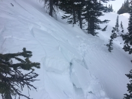
Over the past few day’s strong winds have hammered slopes on all aspects and elevations. There’s still soft snow to be found in protected areas, but fresh lines are rapidly disappearing and conditions are becoming adventurous in the backcountry. Yesterday, skiers up Flanders in Hyalite found generally “obnoxious” conditions with lots of breakable crust. Skiers north of Bridger Bowl also found wind affected snow and triggered a small wind slab near the ridgeline (photo).
Today, wind loading remains the primary avalanche concern. There’s not much snow available for transport, but strong winds continue to form slabs in isolated areas. These slabs will be firm and stubborn, but could still fracture under the weight of a skier or rider. Be especially cognizant of wind drifted snow near ridgelines, cross-loaded gullies and rock bands.
In some areas wind slabs rest over a layer of small grained facets or surface hoar that formed early December. I found this layer in the northern Bridgers on Thursday (video) and Alex found it in the Taylor Fork yesterday (video). This layer is not highly reactive, but is something to look for and assess before committing to steeper terrain.
Today, heightened avalanche conditions exist on steep wind loaded slopes which have a MODERATE avalanche danger. Non-wind loaded slopes have a LOW avalanche danger.
If you get out and have any avalanche or snowpack observations to share, contact us via our website, email (mtavalanche@gmail.com), phone (406-587-6984), or Instagram (#gnfacobs).
Upcoming Avalanche Education and Events
Our education calendar is full of awareness lectures and field courses. Check it out: Events and Education Calendar.
COOKE CITY
Every Friday and Saturday, Rescue Training and Snowpack Update. Friday 6:30-7:30 p.m. at the Soda Butte Lodge. Saturday anytime between 10-2 @ Round Lake.
For hyperlinks to work, click <Cancel> when the box asks you to clean up Word after pasting.
Check out our new “Avalanches and Snowpits” menu item where we list all the reported avalanche activity.