Good morning. This is Eric Knoff with the Gallatin National Forest Avalanche Forecast issued on Saturday, December 29th at 7:15 a.m. Today’s forecast is sponsored by Spark R&D and Cooke City Motorsports . This forecast does not apply to operating ski areas.
Yesterday, the Bridger Range received 8” of low density snow while mountains south of Bozeman including Big Sky received 2-3”. The mountains near Cooke City and West Yellowstone picked up an inch or two. This morning, temps are a few degrees below zero F in the south and 5-10 degrees F in the north. West-northwest winds are blowing 20-40 mph in the mountains around Bozeman and Big Sky and 15-25 mph in the southern ranges. Today, snow and wind will increase across the forecast region. The mountains will see 2-4” by this afternoon with increasing west-northwest winds. Snow continues tonight with another 2-4” possible by tomorrow morning. A stronger storm impacts the area tomorrow with more accumulating snowfall.

Yesterday, my partners and I toured in the mountains above Hebgen Lake near West Yellowstone and found a shallow-weak snowpack (video, photo). On slopes that had thicker slabs of wind drifted snow, we experienced large collapses and shooting cracks. A similar observation came from the Lionhead area, where a snowmobiler experienced cracking and collapsing (photo). These are clear warning signs the snowpack lacks structural integrity and can’t support much weight.
As snow and wind impact the area the next few days, conditions will become increasingly unstable. The best approach to safe riding will be to stay off steep slopes and avoid avalanche run out zones.
Today, human triggered avalanches are possible and the avalanche danger is rated MODERATE. The danger could rise to CONSIDERABLE by this afternoon with the arrival of new snow and wind.
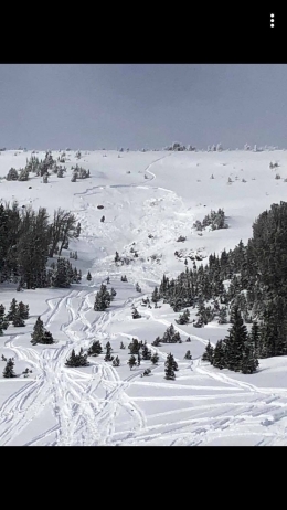
The snowpack around Cooke City contains multiple weak layers capable of producing avalanches. North of town, a layer of facets 1-1.5’ below the surface is the main avalanche concern (video, photo). Yesterday, a snowmobiler triggered a slide on Mt Abundance that most likely failed on this layer (photo). The slide broke 1-1.5’ feet deep, a 100’ wide and funneled into a terrain trap. Fortunately, nobody was caught. However, this slide was easily large enough to injure or bury a skier or rider. Similar avalanches are possible today. The only way to assess the strength and distribution of this weak layer is dig a snowpit and do a stability test. If test results point to instability, stick to lower angle terrain or find a slope with a stronger structure.
South of town, the snowpack is shallower and weaker. On Thursday, Doug toured up Republic Creek and found a faceted snowpack (video). This structure will become increasingly unstable as snow and wind impact the area the next few days. Avoiding steep slopes and avalanche run out zones will be the best way to stay safe with an increasing avalanche danger.
Today, the avalanche danger will start out MODERATE, but could rise to CONSIDERABLE by this afternoon.

The Bridger Cloud worked its magic yesterday delivering 8” of cold smoke powder. Hyalite and Big Sky weren’t as lucky, but still picked up a few inches. This round of low density snow did not put significant stress on a generally stable snowpack, but did provide plenty of ammunition for the development of fresh wind slabs (video).
Today, the primary avalanche concern will be wind loaded slopes. West-northwest winds increased significantly overnight and will remain strong through the day. The combination of strong winds and fresh snow available for transport will create wind slabs that will be easy to trigger. Wind slabs will grow in size and distribution as the day progresses. Watch for signs of instability such as shooting cracks and avoid all steep slopes that have wind drifted snow.
Today, dangerous avalanche conditions exist on wind loaded slopes which have a CONSIDERABLE avalanche danger. Non-wind loaded slopes have a MODERATE avalanche danger.
New webpage dedicated to the Centennial Range in Idaho and Montana
After last season's two snowmobiler avalanche fatalities on Reas Peak in the Centennial Range we created a webpage so riders could get good, relevant information regarding snowpack and avalanches. Although the Centennial Range is not part of the Gallatin National Forest Avalanche Center's forecast area, we are the closest avalanche center and have valuable information to share. More…
Upcoming Avalanche Education and Events
Our education calendar is full of awareness lectures and field courses. Check it out: Events and Education Calendar.
BOZEMAN
January 2, Avalanche Awareness, 6-7:30 p.m. at REI, Bozeman. Pre-register at https://www.rei.com/events.
January 8, Women’s Specific Avalanche Awareness, 6:30-8 p.m. Story Mill Park, Bozeman.
January 9, 1-hr Avalanche Awareness, 7-8 p.m. Spire Climbing Center, Bozeman.
WEST YELLOWSTONE
January 12 and 26, 1-hr Avalanche Awareness for Snowmobilers, 7-8 p.m. Holiday Inn West Yellowstone.
COOKE CITY
Every Friday and Saturday, Rescue Training and Snowpack Update. Friday 6:30-7:30 p.m. at the Soda Butte Lodge. Saturday anytime between 10-2 @ Round Lake.
See Alex’s recent article about the Lift-accessed Backcountry of Saddle Peak. Be prepared with the necessary knowledge and skills before leaving the ski area into this complex and deadly terrain.