Good morning. This is Eric Knoff with the Gallatin National Forest Avalanche Forecast issued on Friday, January 4th at 7:10 a.m. Today’s forecast is sponsored by PH.D. Skis and Beartooth Powder Guides. This forecast does not apply to operating ski areas.
At 5 a.m. temps range from the teens to upper 20’s F under mostly clear skies. West-southwest winds are blowing 25-40 mph in the northern mountains and 15-25 mph in the south. Today, warm and windy conditions will continue. Highs will climb into the upper 20’s to low 30’s F and winds will remain moderate to strong out of the west-southwest. No new snow is expected over the next 24 hours.

Weak faceted snow near the ground continues to make avalanches possible. Yesterday, my partner and I toured around Bacon Rind in the southern Madison Range and experienced large collapses and unstable test results (video). After feeling and hearing entire slopes collapse under our feet, we avoided all slopes steeper than 30 degrees. Although conditions are less touchy than they were earlier in the week (video, photo), I would still suggest avoiding avalanche terrain.
Today, weak facets near the ground capped by a cohesive slab make avalanches possible. For this reason the avalanche danger is rated MODERATE.
Strong winds the past few days have hit all aspects and elevations. Some slopes are stripped and scoured while others are heavily loaded. Watch for thick wind drifts below ridgelines, rock outcroppings, and cross loaded terrain features. Not all wind loaded slopes will be touchy to human triggers. However, avalanches remain possible on slopes where wind deposited snow rests over lower density new snow or faceted layers. Today, carefully assess wind loaded slopes before traveling in avalanche terrain. On upper elevation slopes, a strong snowpack will keep instabilities confined to new and wind-blown snow.
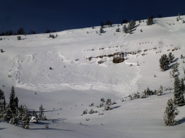
On mid to low elevation slopes, a shallow and weak snowpack continues to produce signs of instability (video, photo). Yesterday, a skier experienced collapsing on a southwest facing slope near Mt Blackmore. Triggering a slide on buried persistent weak layers is becoming less likely without a recent loading event, but is something to consider when traveling on slopes with a shallow and weak snowpack.
Today, human triggered avalanche are possible and the avalanche danger is rated MODERATE.
Without a recent loading event, the snowpack is trending towards stability. The primary avalanche concern will be slopes that got heavily wind loaded earlier in the week (photo). These slopes have had time to gain strength, but still need to be evaluated carefully. Watch for thick wind drifts in exposed terrain loaded by west-northwest winds. Be especially aware of this problem on slopes with terrain traps such as gullies, rock bands, or thick trees. It’s important to remember that small slides can have severe consequences. Outside of wind loaded slopes the snowpack is generally stable.
Today, heightened avalanche conditions exist on wind loaded slopes which have a MODERATE avalanche danger. Non-wind loaded slopes have a LOW avalanche danger.
Upcoming Avalanche Education and Events
Our education calendar is full of awareness lectures and field courses. Check it out: Events and Education Calendar.
BOZEMAN
January 8, Women’s Specific Avalanche Awareness, 6:30-8 p.m. Story Mill Park, Bozeman.
January 9, 1-hr Avalanche Awareness, 7-8 p.m. Spire Climbing Center, Bozeman.
January 16, 17 and 19 or 20, Intro to Avalanches w/ Field Day, Info and Register Here.
January 23, 24 and 26, Advanced Avalanche Workshop w/ Field Day, Info and Register Here.
February 2, King and Queen of the Ridge at Bridger Bowl (fundraiser). Register with Bridger to hike in the event, and create a pledge page to raise funds with your Ridge laps.
WEST YELLOWSTONE
January 12 and 26, 1-hr Avalanche Awareness for Snowmobilers, 7-8 p.m. Holiday Inn West Yellowstone.
DILLON
January 22, 1-hr Avalanche Awareness, 6:30-7:30 p.m. U.M. Western Library.
BILLINGS
January 22, 1-hr Avalanche Awareness, 6-7 p.m. The Base Camp, Billings
COOKE CITY
Every Friday and Saturday, Rescue Training and Snowpack Update. Friday 6:30-7:30 p.m. at the Soda Butte Lodge. Saturday anytime between 10-2 @ Round Lake.
Read Doug’s recent article on Snowmobiler Education Efforts that will be published in the next issue of The Avalanche Review.