Good morning. This is Alex Marienthal with the Gallatin National Forest Avalanche Forecast issued on Saturday, February 9th at 7:00 a.m. Today’s forecast is sponsored by Yellowstone Arctic Yamaha and The Friends of the Avalanche Center. This forecast does not apply to operating ski areas.
This morning the mountains have 2-4” of new snow near Big Sky, West Yellowstone and the Bridger Range, 1” near Cooke City, and zero in Hyalite. Wind is south-southwest at 15-25 mph, except in the Bridger Range where wind is east at 5-15 mph. This morning temperatures are negative single digits to low teens F, and today will reach single digits above zero to low teens F. Wind will be southwest-southeast at 15-25 mph with snow showers this afternoon and tonight. By morning expect 3-5” in the mountains near West Yellowstone and Big Sky with 2-3” elsewhere, and more snow tomorrow.

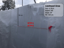
On Thursday Doug and I snowmobiled at Lionhead ridge. From the highway on the drive there we spotted four large avalanches (photo, video). The largest was four feet deep and triggered by snowmobilers on Wednesday (details). Nobody was caught. This avalanche, along with two others (photo, photo), broke on weak sugary facets in the lower third of the snowpack. In the mountains near West Yellowstone and the southern Madison and Gallatin ranges this poor snowpack structure is widespread and makes it possible to trigger a large, destructive avalanche (video, snowpit).
Avalanches breaking 2-4’ deep on sugary facets are becoming more difficult to trigger, but have big consequences. Unfortunately, evaluating slope stability is tricky. Obvious signs the snowpack is unstable are less frequent, such as cracking or collapsing, and multiple people can put tracks on a slope before a large avalanche is triggered. The simplest strategy to avoid large avalanches is to avoid avalanche terrain. Otherwise, you have to confidently rule out the presence of weak, sugary snow buried 2-4’ deep. Today, dangerous avalanches are possible to trigger and avalanche danger is MODERATE.
In the mountains near Bozeman, Big Sky and Cooke City no avalanches have been reported in over a week with only isolated signs of unstable buried weak layers. Today it is unlikely you will trigger an avalanche on weak layers in the middle or bottom of the snowpack. However, before riding steep terrain it is worth digging 3-4 feet to evaluate snowpack structure and stability. The weakest and potentially unstable slopes are where the snowpack is relatively shallow, less than 4 feet (video, video), or where snow depth changes greatly across a slope due to variation in wind loading.
A more likely, though less consequential type of avalanche is small drifts formed from moderate southerly and east wind (photo). These small slabs are possible near ridgelines and should be avoided where a small slide could carry you into trees, over cliffs, or through other hazardous terrain. Cracking of the snow surface is an obvious sign these drifts are unstable. Be on the lookout for these slabs in unusual locations due to less common east winds. Today, small fresh drifts of snow are likely and wind loaded slopes have a MODERATE avalanche danger. Avalanche danger is LOW on non-wind loaded slopes.
If you get out and have any avalanche or snowpack observations to share, contact us via our website, email (mtavalanche@gmail.com), phone (406-587-6984), or Instagram (#gnfacobs).
Story Mill Beacon Park
Stop by the public beacon park at the Bozeman Parks North Recreation Center at Story Mill on Rouse St. It is operational from 8:30 a.m to 5:00 p.m. 7 days a week. Here’s a fun video outlining how to use the park: https://www.facebook.com/friendsgnfac/videos/279522799401278/
Upcoming Avalanche Education and Events
Our education calendar is full of awareness lectures and field courses. Check it out: Events and Education Calendar.
BOZEMAN
February 22 and 23, Women’s Companion Rescue Clinic, 6-8 p.m. Friday at REI, 10-4 Saturday in the field. More Info and Register.
WEST YELLOWSTONE
TONIGHT, and February 16 and 23, 1-hr Avalanche Awareness for Snowmobilers, 7-8 p.m. Holiday Inn West Yellowstone.
HELENA
February 13, 1-hr Avalanche Awareness, 6-7 p.m. at Carroll College.
COOKE CITY
Every Friday and Saturday, Rescue Training and Snowpack Update. Friday 6:30-7:30 p.m. at the Soda Butte Lodge. Saturday anytime between 10-2 @ Round Lake.
Read an article in Backcountry Magazine by Mark Staples of the Utah Avalanche Center about why it’s a good idea to dig quick pits.