Good morning. This is Doug Chabot with the Gallatin National Forest Avalanche Forecast issued on Wednesday, February 13th at 7:00 a.m. Today’s forecast is sponsored by Cooke City Super 8/Bearclaw Bob’s and Lawson Dental. This forecast does not apply to operating ski areas.
At 5 a.m. there is 6” of new snow in Taylor Fork and 3-4” in Lionhead and Cooke City. Mountain temperatures are in the teens and winds are strong out of the west to southwest, averaging 20-30 mph with gusts exceeding 50 mph. Snowfall will blanket our area today and by morning I expect 6-8” in the mountains around Bozeman and Big Sky and a foot near West Yellowstone and Cooke City. Winds will remain strong and snow looks to continue into tomorrow.

The mountains south of Big Sky to West Yellowstone are getting snow and strong winds, a one-two punch that will keep avalanche conditions dangerous. A couple feet has fallen over the last 5 days and westerly winds have drifted snow into thick drifts which are ripe to avalanche. Last Thursday, Alex and I saw avalanches in Lionhead (details) that broke near the ground and were large. Slopes that have not avalanched yet, may be approaching their breaking point with today’s snowfall. Stay clear of avalanche terrain. Avalanches can be triggered from flat areas at the bottom of slopes making travel especially dangerous. For today, both natural and human triggered slides are on the menu and the avalanche danger is rated CONSIDERABLE on all slopes.
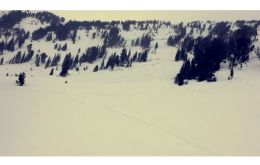
The mountains around Cooke City are getting snow and wind. They received a foot of snow in the last two days and will receive at least that in the next 24 hours. The main concern is wind-loaded slopes on many aspects an elevations. I had cracks shooting out in thin wind drifts on Monday, and yesterday skiers saw small wind drifts that avalanched (photo). These drifts will be more numerous, thicker and touchier today.
The snowpack is strong and stable in many areas (photo, snowpit), yet unstable in a few others. Weak layers mid-pack, and near the ground in shallow areas have the potential to avalanche as evidenced by Saturday’s snowmobiler triggered slide on the south face of Mt. Abundance (details and photos). For today, the avalanche danger is CONSIDERABLE on wind-loaded slopes and MODERATE on all others.

The northern ranges have no new snow, but I anticipate that will change this morning. Wind, on the other hand, is plentiful. In Hyalite, southwest winds are gusting over 50 mph. Wind-drifts will be found at many elevations and aspects and I anticipate a skier or rider could trigger one. In areas with shallower snowpacks (4 feet or less) there are still sugary facets in the lower half. Although we have not seen avalanches on this layer in two weeks, it remains a concern as Ian outlined in his video on Buck Ridge. Skiers on Little Ellis yesterday saw no signs of instability, but still notched back their plans when the facets broke in their tests 1.5 feet above the ground. For today the danger is rated MODERATE on wind-loaded slopes and LOW on all others.
Upcoming Avalanche Education and Events
Our education calendar is full of awareness lectures and field courses. Check it out: Events and Education Calendar.
BOZEMAN
February 22 and 23, Women’s Companion Rescue Clinic, 6-8 p.m. Friday at REI, 10-4 Saturday in the field. More Info and Register.
WEST YELLOWSTONE
February 16 and 23, 1-hr Avalanche Awareness for Snowmobilers, 7-8 p.m. Holiday Inn West Yellowstone.
HELENA
February 13, 1-hr Avalanche Awareness, 6-7 p.m. at Carroll College.
COOKE CITY
Every Friday and Saturday, Rescue Training and Snowpack Update. Friday 6:30-7:30 p.m. at the Soda Butte Lodge. Saturday anytime between 10-2 @ Round Lake.
This video interviewing one of the party members involved in Saturday’s fatal avalanche in Utah is a sobering account of a tragic accident.