Good morning. This is Eric Knoff with the Gallatin National Forest Avalanche Forecast issued on Friday, February 15th at 7:00 a.m. Today’s forecast is sponsored by Yellowstone Arctic Yamaha in partnership with the Friends of the Avalanche Center. This forecast does not apply to operating ski areas.
Over the past 24 hours the mountains around Cooke City, West Yellowstone and Big Sky picked up 6-7” of new snow while the mountains around Bozeman received 2-3”. At 5 a.m. light snow continues down south with dry conditions in the north. Temps are in the 20’s F under cloudy skies and winds are blowing 15-25 mph out of west-southwest. Light snow continues in the south with 2-3” possible by this afternoon, the northern mountains could see 1-2”. A heavier band of snow arrives this evening with an additional 3-5” likely across the forecast area.
The avalanche warning has expired, but dangerous avalanche conditions remain. Over the past three days, the southern mountains picked up over two feet of snow totaling 1.5-2” of SWE (video). Today, natural and human triggered avalanches are likely on all wind loaded slopes. Areas loaded by west-southwest winds will be the most susceptible to holding wind drifted snow.
Human triggered avalanches are also likely on non-wind loaded slopes. Slides breaking 1-3’ deep on density changes in the new snow will be easy to trigger. Slides could also break 3-5’ deep on weak layers near the ground (photo). During these conditions, avoiding steep slopes and avalanche run out zones is essential. This includes staying off small steep slopes like road cuts and creek beds that may seem harmless during more stable conditions.
Today, very dangerous avalanche conditions exist on wind loaded slopes which have a HIGH avalanche danger. Non-wind loaded slopes have a CONSIDERABLE avalanche danger.

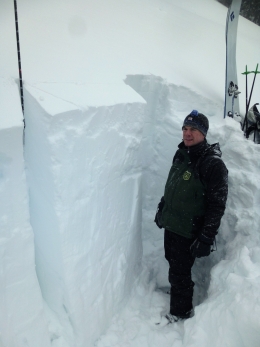
Storm totals over the past three days for the Cooke City area are 1.5-2’ of snow totaling roughly 2” of SWE. The snowpack around Cooke City is stronger than the pack around West Yellowstone (photo), but this heavy load is enough to create unstable conditions. Wind loaded slopes will be the most likely to produce human triggered avalanches today. Watch for and avoid areas of wind drifted snow in terrain loaded by west-southwest winds. Cracking/collapsing and recent avalanches are obvious signs the snowpack is unstable. Slides will likely stay confined to new and wind-blown snow, but the possibility remains for slides to break on weak layers buried mid pack and near the ground. This scenario is most likely in areas with a shallower and weaker snowpack. Today, careful snowpack evaluation and conservative decision making are essential.
As the snowpack works to adjust, human triggered avalanches are likely and the avalanche danger is rated CONSIDERABLE.
The mountains around Big Sky picked up 6” of snow overnight while the Bridger Range and northern Gallatin Range received 2-4”. This shot of snow isn’t enough to create widespread instability, but it will bump up the danger on wind loaded slopes. Temps are on the warm side, which will make fresh wind slabs denser and potentially harder to trigger. Watch for and avoid this problem on mid to upper elevations slopes loaded by west-southwest winds. Fresh wind slabs won’t produce large and destructive avalanches, but they will pack enough punch to carry and potentially burry a skier or rider (photo). Be especially cognizant of this problem when skiing or riding in higher consequence terrain. Fortunately, weak layers near the ground are gaining strength (video), which should keep slides confined to new and wind drifted snow.
Today, human triggered avalanches are likely on wind loaded slopes which have a CONSIDERABLE avalanche danger. Non-wind loaded slopes have a MODERATE avalanche danger.
If you get out and have any avalanche or snowpack observations to share, contact us via our website, email (mtavalanche@gmail.com), phone (406-587-6984), or Instagram (#gnfacobs).
Avalanche Warning
Upcoming Avalanche Education and Events
Our education calendar is full of awareness lectures and field courses. Check it out: Events and Education Calendar.
BOZEMAN
February 22 and 23, Women’s Companion Rescue Clinic, 6-8 p.m. Friday at REI, 10-4 Saturday in the field. More Info and Register.
WEST YELLOWSTONE
February 16 and 23, 1-hr Avalanche Awareness for Snowmobilers, 7-8 p.m. Holiday Inn West Yellowstone.
COOKE CITY
Every Friday and Saturday, Rescue Training and Snowpack Update. Friday 6:30-7:30 p.m. at the Soda Butte Lodge. Saturday anytime between 10-2 @ Round Lake.
The Friends of the Avalanche Center and Montana State Parks installed an avalanche danger sign outside Cooke City. It sits next to the beacon checker and will be seen by riders and skiers as they head out of town.