Good morning. This is Alex Marienthal with the Gallatin National Forest Avalanche Forecast issued on Sunday, February 17th at 7:00 a.m. Today’s forecast is sponsored by Cooke City Motorsports and Highline Partners. This forecast does not apply to operating ski areas.
This morning the mountains have a trace to 1” of new snow near Bozeman, Big Sky and West Yellowstone with 2-3” near Cooke City. Yesterday, wind was west-southwest at 15-20 mph with gusts near Bozeman and Big Sky to 40 mph. Today, wind is 0 to 10 mph and will shift east this afternoon. Temperatures are single digits F this morning, and today they will be single digits to low teens F. Light snow showers this afternoon and tonight will drop 1-2” by tomorrow morning.

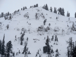
Since last Saturday the mountains near West Yellowstone and the southern Madison and Gallatin ranges received 3-4’ of snow equal to 3-3.5” of snow water equivalent (SWE). Snowfall slowed down the last couple days and allowed weak layers at the base of the snowpack to adjust to the added stress (weather log). Eric rode in Taylor Fork yesterday and saw a cornice triggered avalanche that broke at the base of the snowpack and deposited debris 10’ deep (photo, video). Today it is possible to trigger deep and wide avalanches that break on weak, sugary facets near the ground (photo). These are getting difficult to trigger and might not break until the second, third or tenth track on the slope. They are more likely on wind loaded slopes. Cornices have doubled in size over the last couple weeks and could fall and trigger a large avalanche (photo). Avoid steep wind loaded slopes and be extra cautious of travel on and underneath all steep slopes. Today, avalanche danger is CONSIDERABLE on wind loaded slopes and MODERATE on non-wind loaded slopes.

Near Cooke City the last two days I was able to trigger avalanches on small test slopes (photo). These are a sign that new snow and fresh drifts are unstable, and to avoid bigger steep terrain. Today near Cooke City avalanches of new snow 1-2’ deep are possible to trigger (photo). Carefully assess the stability of new snow and fresh drifts before riding steep slopes. Look for cracking of the snow surface as a sign these slabs are easy to trigger. Yesterday we looked at a large avalanche that occurred Friday (video, details). This slide was triggered by a large cornice falling onto a heavily wind loaded slope, and it broke on sugary facets near the base of the snowpack. Large avalanches like this are possible on specific slopes, which are heavily wind loaded. To avoid this type of slide avoid heavily wind loaded slopes, which are often identified by large cornices above them. Today, avalanches are possible to trigger and avalanche danger is MODERATE.
Yesterday a skier in the Bridger Range triggered multiple avalanches 8-12” deep that ran 700’ and broke small trees (photo, photo). The mountains near Bozeman and Big Sky received up to a foot of snow since Wednesday, and the last couple days moderate wind drifted new snow into soft slabs that were easy to trigger. Today, avalanches of new and wind drifted snow are possible to trigger. Carefully assess the stability of recent snow before riding steep slopes. Look for cracks in the snow surface or dig 2-3 feet deep and do a quick extended column test. Avalanche danger is MODERATE on wind loaded slopes and LOW on non-wind loaded slopes.
If you get out and have any avalanche or snowpack observations to share, contact us via our website, email (mtavalanche@gmail.com), phone (406-587-6984), or Instagram (#gnfacobs).
Upcoming Avalanche Education and Events
Our education calendar is full of awareness lectures and field courses. Check it out: Events and Education Calendar.
BOZEMAN
February 22 and 23, Women’s Companion Rescue Clinic, 6-8 p.m. Friday at REI, 10-4 Saturday in the field. More Info and Register.
March 1, 2 and 3, Bozeman Split Fest, More info at www.bozemansplitfest.com.
WEST YELLOWSTONE
February 23, 1-hr Avalanche Awareness for Snowmobilers, 7-8 p.m. Holiday Inn West Yellowstone.
COOKE CITY
Every Friday and Saturday, Rescue Training and Snowpack Update. Friday 6:30-7:30 p.m. at the Soda Butte Lodge. Saturday anytime between 10-2 @ Round Lake.
The Friends of the Avalanche Center and Montana State Parks installed an avalanche danger sign outside Cooke City. It sits next to the beacon checker and will be seen by riders and skiers as they head out of town.