Good morning. This is Eric Knoff with the Gallatin National Forest Avalanche Forecast issued on Saturday, February 23rd at 7:00 a.m. Today’s forecast is sponsored by Yellowstone Ski Tours and Gallatin Valley Snowmobile Association. This forecast does not apply to operating ski areas.
This morning there’s no new snow to report and temperatures are in the single digits above or below zero F. Winds are blowing 15-25 mph out of the west-southwest with gusts in Hyalite breaking 30 mph. Today, skies will become mostly cloudy and temps will warm into the upper teens to low 20’s F. Winds will continue to blow 15-30 mph shifting to the west-northwest by this afternoon . Light snow develops this evening and the mountains will see 2-4” by tomorrow morning. A heavier shot of snow impacts the region tomorrow into Monday.

No avalanches have been reported in the southern mountains over the past four days. The reason for the decline in activity is the absences of a recent loading event. Although the snowpack is well adjusted and avalanches are becoming less likely, they still remain possible. The primary avalanche concern is a persistent weak layer of facets buried a foot or two off the ground. This layer has been the culprit for numerous large avalanches over the past ten days (video, details and photos).
Assessing the strength and distribution of deeply buried weak layers isn’t easy. The best defense against trigging a deep slab avalanche is to avoid riding steep slopes, especially those beneath cornices or in steep rocky terrain. It’s important to remember that tracks on a slope do not indicate stability. If a slide is triggered today, it will likely be large and dangerous. Shallow wind slabs on upper elevation slopes loaded by westerly winds will also be a growing concern as winds increase throughout the day.
Buried weak layers and increasing winds make human triggered avalanches possible and the avalanche danger is rated MODERATE.
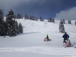
Wind slabs on upper elevation slopes loaded by west-southwest winds will be the main concern today (photo). These slabs won’t be exceptionally large, but could break 1-2’ deep. Managing this problem shouldn’t be too difficult. Watch for and avoid areas of wind drifted snow beneath cornices, cliff bands, and cross loaded terrain features. Winds are forecasted to increase through the day making wind slabs more widespread. Active wind loading is a clear indicator instability is on the rise, a warning sign to steer clear of steep wind loaded slopes.
There is an isolated chance a skier or rider could trigger a slide breaking on facets near the ground. Watch for this problem in areas where the snowpack is thinner or on slopes that have been heavily wind loaded. A few a slides earlier in the week are a reminder this problem is still lurking (photo, photo, video).
Today, human triggered avalanches are possible on wind loaded slopes which have a MODERATE avalanche danger. Non-wind loaded slopes have a LOW avalanche danger.
Upcoming Avalanche Education and Events
Our education calendar is full of awareness lectures and field courses. Check it out: Events and Education Calendar.
BOZEMAN
March 1, 2 and 3, Bozeman Split Fest, More info at www.bozemansplitfest.com.
WEST YELLOWSTONE
February 23, 1-hr Avalanche Awareness for Snowmobilers, 7-8 p.m. Holiday Inn West Yellowstone.
COOKE CITY
Every Friday and Saturday, Rescue Training and Snowpack Update. Friday 6:30-7:30 p.m. at the Soda Butte Lodge. Saturday anytime between 10-2 @ Round Lake.
On Tuesday, a backcountry skier ascending a trail near Telluride, Colorado was buried and killed by an avalanche triggered by a rider descending above him. Preliminary details and photographs here.