Good morning. This is Alex Marienthal with the Gallatin National Forest Avalanche Forecast issued on Monday, February 25th at 7:00 a.m. Today’s forecast is sponsored by Gallatin County Search and Rescue and Stronghold Fabrication. This forecast does not apply to operating ski areas.
AVALANCHE WARNING
The Gallatin National Forest Avalanche Center is issuing a Backcountry Avalanche Warning for the Lionhead area near West Yellowstone and the Centennial Range. Heavy snowfall and strong wind are creating very dangerous avalanche conditions. Natural and human triggered avalanches are likely. Avalanche terrain and avalanche runout zones should be avoided. The avalanche danger is rated HIGH on all slopes.
Since yesterday the mountains received 20” of snow near West Yellowstone, 12-14” south of Big Sky and near Cooke City, and 4-6” near Bozeman and Big Sky. Temperatures this morning are negatives and single digits F near Bozeman, and teens to low 20s F elsewhere. Wind has been southwest at 20-30 mph with gusts of 40-50 mph, and 5-15 mph in the Bridger Range. Today, temperatures will be teens to low 20s F and wind will be southwest at 20-35 mph. Snow showers will continue and by morning the mountains will have 12-20” of new snow near West Yellowstone and Cooke City with 5-8” near Bozeman and Big Sky.
Avalanche Warning
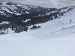
Since yesterday morning the mountains near West Yellowstone received more than 20” of snow equal to 2.2” of snow water equivalent (SWE). Strong southwest wind drifted this snow into thick unstable slabs, which will continue to grow with snow and wind today. Large avalanches of new and wind-drifted snow are likely on all steep slopes and will break naturally. This rapid, heavy load will test the strength of weak layers buried 4-6’ deep at the base of the snowpack, and very large avalanches are possible (video, video). Avoid all steep slopes and runout zones below. Avalanche danger is HIGH on all slopes.
The southern Madison and Gallatin ranges and mountains near Cooke City received more than a foot of new snow equal to 1.2”-1.4” of SWE. Overnight, strong southwest wind formed 2-3’ thick drifts that are easy to trigger and can avalanche naturally. Avoid travel on and underneath steep slopes adjacent to scoured ridgelines or below large cornices. Though less likely, avalanches breaking on sugary persistent weak layers are possible, similar to the large slides ten days ago on Henderson Mountain (details) and in the Taylor Fork (details). On non-wind loaded slopes, storm slabs 1-2’ thick and loose snow avalanches are easy to trigger and large enough to bury a person. Stability will decrease with more snow and wind today. Avalanche danger is HIGH on wind loaded slopes and CONSIDERABLE on all other slopes.

Yesterday Doug and I toured north of Bridger Bowl. There was no wind loading or cracking of the snow surface to indicate unstable soft slabs, and the main concern was loose snow avalanches (video). Ian found similar conditions in Beehive (video). Since yesterday the mountains near Bozeman and Big Sky received 4-6” of snow equal to .2-.6” of SWE. Strong wind formed fresh drifts that are possible to trigger and will grow larger and more unstable with snow and wind today. Watch for blowing and drifting snow and cracking of the snow surface as signs to avoid steep, wind-loaded terrain. There is an isolated chance you could trigger a deep avalanche on buried weak layers (photo, photo, video). The most suspect slopes are heavily wind loaded, or where the snowpack is relatively shallow (less than 3-5 feet). Today, new low density snow and strong wind make avalanches possible and avalanche danger is MODERATE.
If you get out and have any avalanche or snowpack observations to share, contact us via our website, email (mtavalanche@gmail.com), phone (406-587-6984), or Instagram (#gnfacobs).
Upcoming Avalanche Education and Events
Our education calendar is full of awareness lectures and field courses. Check it out: Events and Education Calendar.
BOZEMAN
March 1, 2 and 3, Bozeman Split Fest, More info at www.bozemansplitfest.com.
March 6, 1-hr Avalanche Awareness, 6-7 p.m. at REI Bozeman.
ENNIS
February 28 and March 3, Intro to Avalanches w/ Field Day, More Info and Register Here.
COOKE CITY
Every Friday and Saturday, Rescue Training and Snowpack Update. Friday 6:30-7:30 p.m. at the Soda Butte Lodge. Saturday anytime between 10-2 @ Round Lake.
On Tuesday, a backcountry skier ascending a trail near Telluride, Colorado was buried and killed by an avalanche triggered by a rider descending above him. Preliminary details and photographs here.