Good morning. This is Eric Knoff with the Gallatin National Forest Avalanche Forecast issued on Friday, March 22nd at 6:30 a.m. Today's forecast is sponsored by Lawson Dental and Alpine Orthopedics. This forecast does not apply to operating ski areas.
This morning temps range from the upper 20’s to low 30’s F under mostly clear skies. Winds are blowing 10-20 mph out of the east-southeast in the northern mountains and 10-20 mph out of the north-northeast in the south. Today, temps will warm into the upper 30’s to mid-40’s F and winds will shift to the southwest blowing 20-30 mph. Skies will become partly to mostly cloudy by this afternoon. Increasing precipitation tonight will drop 1-2” of snow in the southern mountains by tomorrow morning.

All Regions
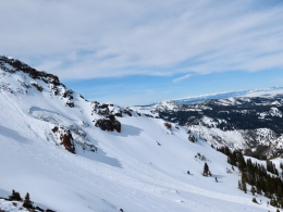
Daytime warming and weak refreezes at night are taking a toll on the snowpack. Over the past few days, widespread avalanche activity has been observed across the forecast area and more action is likely today. Most activity has been confined to wet snow avalanches occurring on steep sun exposed slopes, but a recent dry slab avalanche on the north face of Mt Blackmore indicates all slopes are feeling the heat (photo). Dry slab avalanches on high north facing slopes are not a widespread problem. Yesterday, my partner and I found soft-stable snow on upper elevation shady slopes in the southern Madison Range.
Today, point release avalanches will be easy to trigger or could run naturally as the day warms (photo, video). Wet slab avalanches are a less likely but a more dangerous problem. Wet slabs are unpredictable and can run with a tremendous amount of force. Yesterday, skiers north of Bridger Bowl observed large wet slab and wet loose avalanches on many slopes (photo, photo). Be especially aware of both these problems in steep rocky terrain or on slopes where the snowpack is less than 3-4 feet deep (video).
The easiest way to manage the avalanche danger today is to start early and end early. The snowpack will be locked up this morning, but grow increasingly unstable as the day progresses. Fortunately, increasing clouds and wind this afternoon should help the snowpack from completely falling apart.
For today, the avalanche danger will start LOW, but rise to MODERATE by this afternoon.
If you get out and have any avalanche or snowpack observations to share, contact us via our website, email (mtavalanche@gmail.com), phone (406-587-6984), or Instagram (#gnfacobs).
Spring is here and wet snow avalanches are becoming a daily concern. Anticipate decreasing stability while forming a travel plan. This article from Backcountry Magazine highlights some things look for that indicate when it is time to turn around.