Good morning. This is Alex Marienthal with the Gallatin National Forest Avalanche Forecast issued on Sunday, April 7th at 7:00 a.m. This is our 129th and last daily forecast of the season. Today's forecast is dedicated to our supporters that read the advisories; took an avalanche class; donated money, time or gear; or sent in observations. Our success is directly related to community support and the Forest Service. Thank you for 29 great seasons. This forecast does not apply to operating ski areas.
Since yesterday morning scattered snow showers delivered 1-2” of snow to the mountains. Yesterday temperatures reached 30s to low 40s F, and this morning temperatures are high 20s to low 30s F. Overnight, southwest wind increased to 20-30 mph with gusts of 45-55 mph. Today wind will remain strong at 30-50 mph out of the southwest-west. Temperatures will reach high 30s to low 40s F with light snow this morning, possible rain this afternoon and a mix of precipitation this evening. By morning, 1-2” of new snow is possible at higher elevations with 4-6” possible near Cooke City.

All Regions
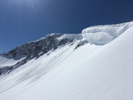
Avalanches will be mostly confined to new snow where the snowpack is frozen underneath 4-6” inches of recent snow (photo). Strong southwest wind will grow large drifts that are possible to trigger and could be large enough to bury a person. Watch for cracking of the snow surface as a sign to avoid steep wind loaded slopes.
Wet loose avalanches of new snow are possible if the snow surface is moist or wet, and they can run far on the underlying crust. Rollerballs or pinwheels are a sign that the snow surface is becoming wet and there is an increasing chance of wet loose avalanches. Move to slopes with dry snow or lower angle terrain if the snow surface is wet.
On lower elevation slopes the snowpack is unsupportable and not frozen due to rain yesterday and multiple nights of above freezing temperatures. Deeper wet snow avalanches are possible on these slopes. Travel is difficult on slopes with this wet snowpack as your skis and boots will sink deep in wet snow. Be cautious of steep terrain above you where wet snow avalanches could start as the day warms up or if rain falls and weakens the snowpack.
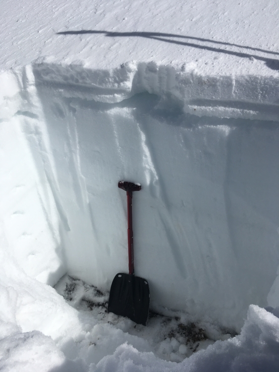
Yesterday we toured on the west side of the Bridger Range. On upper elevation slopes (>7,500’) we found new snow on a supportable crust (video). The new snow bonded well to the crust, and clouds in the afternoon prevented wet snow activity. Today, warmer temperatures and potential rain make wet avalanches possible on all steep slopes.
Snow stability can be simple to identify, but spring weather adds complex variables. The best and safest place to travel is where the snow surface is dry (and not wind-loaded) and the underlying snowpack is frozen and supportable. Avoid steep slopes where the snowpack is unsupportable and not frozen, or where the snow surface becomes wet due to rain or above freezing temperatures. Carefully monitor the weather, and anticipate rapidly changing conditions throughout the day and as you change aspect or elevation.
Today, warm temperatures and strong wind make both wet and dry snow avalanches possible and avalanche danger is MODERATE.
If you get out and have any avalanche or snowpack observations to share, contact us via our website, email (mtavalanche@gmail.com), phone (406-587-6984), or Instagram (#gnfacobs).
Info and Announcements
We will issue weather and snowpack updates on Monday and Friday mornings for most of April, and update our weather log daily.
The Hyalite road is closed to motorized travel until May 16th. Bike and foot traffic is allowed.
The Hyalite road is closed to motorized travel until May 16th. Bike and foot traffic is allowed.