Good Morning. This is Dave Zinn with the Gallatin National Forest Avalanche Forecast on Monday, December 28th at 7:15 a.m. This forecast is sponsored by Spark R&D and Cooke City Super 8/Bearclaw Bob’s. This forecast does not apply to operating ski areas.
With no new snow in the last 24-hours, mountain winds are blowing 5-15 MPH from the west and temperatures in the single digits to low teens F. Today, under sunny skies, temperatures will rise into the upper teens F and the wind will blow 5-10 MPH from the north.

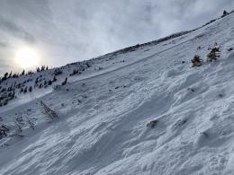
The snowpack in the mountains around West Yellowstone, Big Sky and Bozeman all have a similarly weak structure with a slab of new and wind-drifted snow sitting on top of a weak foundation of sugary facets. A structure like this does not inspire confidence even as the likelihood of human-triggered avalanches goes down as we become further removed from our last snowstorm. The analogy Doug and I made yesterday at Lionhead was that skiing or riding in steep terrain right now is like playing Russian Roulette, but with fewer chambers loaded (video). This analogy applies equally in this portion of our advisory area where we have seen continued signs of instability such as:
- Two large collapses (“whumps”) and unstable test results on our tour at Lionhead Ridge yesterday
- Two large deep slab avalanches triggered by the YC Ski Patrol during yesterday’s avalanche mitigation. One was 600’ wide and 3’ deep, the second broke 5’ deep
- Two different tourers reported loud “whumphs” and shooting cracks in the Southern Gallatin Range
- A large unintentionally triggered avalanche on the Football Field just south of the Bridger Bowl Boundary on Christmas Day (photos and details)
These events correspond to what we have observed in the field. Go through this season’s field video library for discussions about our field observations.
Today, utilize thorough snowpack evaluation and careful route selection that avoids steep terrain. Human triggered avalanches remain a scary possibility and the danger is rated MODERATE.
While the danger rating is the same in Cooke City as in our other areas, the avalanche problem is different because the foundation of the snowpack I s generally strong. Human-triggered avalanches failing 2-3’ deep within the new and wind-drifted snow from the last week of snowstorms are possible in steep, rocky terrain. Watch our videos and read about recent avalanche activity to get an idea of what is possible (video, video, details). The new snow will continue to stabilize but remain vigilant by following safe travel protocols and carrying avalanche rescue gear. Today, watch for signs of instability such as shooting cracks and evaluate the upper few feet of the snowpack by digging and performing a stability test before committing to any avalanche terrain. The avalanche danger is rated MODERATE.
If you get out, please send us your observations no matter how brief. You can submit them via our website, email (mtavalanche@gmail.com), phone (406-587-6984), or Instagram (#gnfacobs).
Upcoming Avalanche Education and Events
See our education calendar for an up to date list of all local classes. Here are a few select upcoming events and opportunities to check out:
Every Saturday in Cooke City, FREE snowpack update and rescue practice at the Round Lake Warming Hut between 10 a.m. and 3 p.m. Poster with More Info.
January 20 & 21 (plus field sessions the following weekends), Avalanche Fundamentals with Field Course. There are separate field sessions tailored for both skiers and splitboarders (Bridger Bowl) and snowmobilers (Buck Ridge). Register here.
A skier at Berthoud Pass in Colorado was buried and killed in an avalanche on Saturday. This the fifth fatality nationally and the fourth in Colorado this season. You can read more about all these tragic incidents here. Be safe out there and continue to take care of each other.