Good Morning. This is Doug Chabot with the Gallatin National Forest Avalanche Forecast on Wednesday, January 6th at 7:30 a.m. This forecast is sponsored by Blitz Motorsports and Yamaha and Grizzly Outfitters. This forecast does not apply to operating ski areas.
Yesterday morning the Lionhead area and Cooke City picked up an additional inch of snow as the snowstorm exited. This morning skies are partly cloudy with mountain temperatures in the mid-teens F. Winds are averaging 15-20 mph with gusts of 35 mph. Today, temperatures will rise into the 20s F under mostly sunny skies with wind speeds decreasing this afternoon to 10-20 mph. No new snow is expected until tomorrow morning.
Last night I added 11 entries to our Avalanche Activity list. Natural and human triggered slides, and red flags of collapses and cracking were littered throughout southwest Montana. Check these out along with our videos leading up to yesterday’s Avalanche Warning to get an understanding of the snowpack structure and instability.

The Avalanche Warning in the southern Madison, southern Gallatin and Lionhead areas has expired. These mountains have a weak snowpack with its bottom third composed of unstable sugary facets. This structure is unsupportable making it easy to poke a ski pole to the ground or dig your track to the dirt. Yesterday, this area got 9” of snow with .8” of snow water equivalent (SWE) which spiked the danger. Avalanches were seen on Lionhead Ridge. Before the storm, widespread whumpfing and collapses were felt throughout all three ranges. Dave forewarned us of the increasing danger in his video on Monday. This was the area’s largest storm since mid-November and today the snowpack will still be adjusting to the added weight of the new snow. Avoid getting on or underneath avalanche terrain because triggering slides is likely today and the danger is rated CONSIDERABLE.
The Avalanche Warning for the Bridger Range has expired. Yesterday morning’s 9” of snow with .8” SWE fell with strong wind. Avalanches occurred during the storm and wind continues to load slopes. Saddle Peak avalanched for the second time in 5 days, and the adjacent slope, Argentina Bowl, also slid (details: Saddle, Argentina). Avalanches released a couple feet deep on sugary facets that underlie most slopes in the range. Ian and I went to the Fairy Lake/Frazier Basin area and watched slopes get stripped by gale winds on one aspect and loaded onto another (video). They were loading at the ridgetop from the west, and southerly at mid-mountain. Today, these newly formed wind drifts should be avoided as they will easily crack and avalanche. For today the avalanche danger is rated CONSIDERABLE on all wind-loaded slopes and MODERATE on all others.

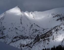
The snowpack in the northern Madison and northern Gallatin Ranges struggled to hold yesterday’s storm snow (9” near Big Sky, 4-6” in Hyalite). Yesterday, a natural avalanche on Fan Mountain (photo) near Big Sky and a sizable crack and collapse in Lick Creek in Hyalite (photo) illustrate the weakness of the snowpack. A thick layer of faceted, sugary snow near the ground was under strain from the weight of the new snow. The layer is still weak, but without active loading the chances of triggering a slide has lessened. No matter, it is still prudent to be conservative, especially on wind-loaded slopes, where triggering slides is still possible. For today, the avalanche danger is MODERATE on all slopes.
The mountains around Cooke City lack widespread weak layers, however, avalanches are still possible. This means just you’ll have to dig and test the snow and travel with your senses keen to whumpfs and collapses, a sign of unstable snow underfoot. Yesterday, a natural avalanche on Mineral Mountain (details), a skier-triggered slide on Henderson Mountain (details), as well as red flags of collapses and cracks are evidence of isolated weakness and lurking instability. For today, the avalanche dangerous rated MODERATE.
If you get out, please send us your observations no matter how brief. You can submit them via our website, email (mtavalanche@gmail.com), phone (406-587-6984), or Instagram (#gnfacobs).
Upcoming Avalanche Education and Events
See our education calendar for an up to date list of all local classes. Here are a few select upcoming events and opportunities to check out:
Every Saturday in Cooke City, FREE snowpack update and rescue practice at the Round Lake Warming Hut between 10 a.m. and 3 p.m. Poster with More Info.
Friday night and Saturday, January 8 & 9. The Friends of the Avalanche Center are teaching a Companion Rescue Clinic. Learn about avalanche terrain, weather, decision-making and rescue. Get more information and register HERE.
Monday, January 11, 6-7 p.m. The Friends of the Avalanche Center will offer a FREE 1-hr Avalanche Awareness Talk in partnership with Uphill Pursuits. The talk will be given via a live ZOOM session. Please click the link below to join the webinar: Join HERE.
Tuesday, January 19, 6-7 p.m. The Friends of the Avalanche Center will offer a FREE 1-hr Avalanche Awareness Talk in partnership with the University of Montana Western School of Outreach. The talk will be a live, ONLINE event. Join us HERE.
January 20 & 21 (plus field sessions the following weekends), Avalanche Fundamentals with Field Course. There are separate field sessions tailored for both skiers and splitboarders (Bridger Bowl) and snowmobilers (Buck Ridge). Register here.
Teton County Search and Rescue in Jackson, WY just released a great 2 min video titled Check Yourself, Check Your Friends: Every Single Time. It is a good reminder to be diligent in our preparation.