Good Morning. This is Doug Chabot with the Gallatin National Forest Avalanche Forecast on Thursday, January 14th at 7:00 a.m. This forecast is sponsored by Grizzly Outfitters and Montana Chevy Dealers. This forecast does not apply to operating ski areas.
In the last 24 hours the mountains around Cooke City got 10” of new snow, 3-4” around West Yellowstone, and 2” outside Bozeman and Big Sky. West wind was vicious yesterday and hit 70-90 mph at the ridgeptops at all our stations. These lessened overnight and now average 15-20 mph with gusts of 40-50 mph. Today will be clear skies, no snow and west wind at 15-25 mph. Temperatures this morning are 10-15F and will warm into the mid 20s this afternoon.

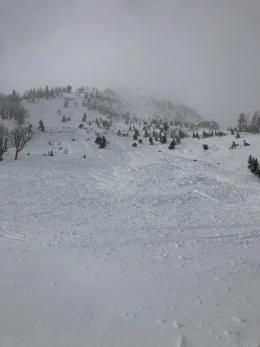
In the last 48 hours the mountains around Bozeman and Big Sky got 3”, Taylor Fork 4” and 8” outside West Yellowstone. Yesterday’s gale-force wind scoured ridgetops and loaded slopes at all elevations and aspects. Snow was redistributed with no predictable pattern. The snowpack is weak and the recent snowfall and wind-loading has made it unstable. Again yesterday, facets at the ground were breaking on low-angled terrain with whumpfs and cracks (S. Gallatin, N. Madison). On steeper slopes a large avalanche was seen on the east side of Lionhead Ridge (photo), which is on the heels of a dozen avalanches my partner and I noted on Tuesday (video). Furthermore, the Bridger Bowl Ski Patrol saw 2 fresh slides on the west side of the Bridger Range in Bostwick and Truman Gulch yesterday (details).
Avoid avalanche terrain today. Evidence continues to show that new snow, even a few inches, has a nasty habit of avalanching. Yesterday’s wind gave the mountains a villainous beating. New drifts are packed densely and will crack and avalanche. Triggering avalanches below or adjacent to a steep slope is possible, just as the skiers in Flanders Creek found on Saturday (if you haven’t seen the video, you need to). Dave explains a rationale for sticking to low-angeled powder in his video at Bacon Rind. For today, the avalanche danger is rated CONSIDERABLE on all slopes since triggering slides is likely.
Yesterday’s snowfall buried a layer of surface hoar (large feathers of snow) that is a notorious weak layer. We will be digging and searching for this layer as we get more snow in the coming weeks, and you should too.
The mountains around Cooke City got 10” yesterday and 3” the day before (1.2” snow water equivalent). Our concerns involve instabilities in the top 3’ of the snowpack:
- Recent wind drifts,
- A weak layer of surface hoar that just got buried,
- A layer of weak, faceted snow 2-3’ deep has been triggered on some slopes.
The snowpack has gotten more complex and requires digging and testing to determine its stability. Given the new snow, strong wind and buried weak layers, slopes will be reactive to triggering. Stay out of avalanche terrain and be vigilant since a new weak layer of surface hoar was buried. It will take time to get a sense of its distribution, but for now we assume it is everywhere. For today the avalanche danger is rated CONSIDERABLE on all slopes.
If you get out, please send us your observations no matter how brief. You can submit them via our website, email (mtavalanche@gmail.com), phone (406-587-6984), or Instagram (#gnfacobs).
Upcoming Avalanche Education and Events
See our education calendar for an up-to-date list of all local classes. Here are a few select upcoming events and opportunities to check out:
Every Saturday in Cooke City, FREE snowpack update and rescue practice at the Round Lake Warming Hut between 10 a.m. and 3 p.m. Poster with More Info.
January 15 and 16, Companion Rescue Clinic, 6-8 p.m. Friday Zoom online, Saturday field session 10am - 2pm. Register HERE.
Tuesday, January 19, 6-7 p.m. The Friends of the Avalanche Center will offer a FREE 1-hr Avalanche Awareness Talk in partnership with the University of Montana Western School of Outreach. The talk will be a live, ONLINE event. Join us HERE.
January 20 & 21 (plus field sessions the following weekends), Avalanche Fundamentals with Field Course. There are separate field sessions tailored for both skiers and splitboarders (Bridger Bowl) and snowmobilers (Buck Ridge). Register here.
Ski-Doo is offering free avalanche education classes online that you can take here: https://www.ski-doo.com/avalanche.html