Good Morning. This is Doug Chabot with the Gallatin National Forest Avalanche Forecast on Wednesday, February 3rd at 7:30 a.m. Today's forecast is sponsored by The First National Bank of Gilbert (Minnesota) and Ph.D. Skis. This forecast does not apply to operating ski areas.
Snowfall started at midnight and by 5 a.m. the mountains around Bozeman to Big Sky and West Yellowstone have 4-6” with 3” in Cooke City. Temperatures are in the low 20s F and wind is W-SW averaging 15-20 mph with gusts of 40 mph. Today will remain snowy with SW wind averaging 10-20 mph and gusts into the 30s. Temperatures will remain in the 20s F. By morning I expect 4-6” in the northern ranges and Cooke City and 2-4” south of Big Sky to West Yellowstone.

In the Bridger, Gallatin and Madison Ranges and Lionhead area, 4-6” fell in three hours measuring .5” of snow water equivalent-SWE. The snowpack was loaded quickly and more snow today will continue raising the avalanche potential. Ian toured into the Throne of the northern Bridger Range yesterday and found conditions to be dismal: thin and weak. In his video he describes a poor snow structure which will be especially untrustworthy with today’s new snow.
Since Friday there have been 14 reports of avalanche activity, some noting multiple slides. These were breaking on weak layers buried in the snowpack: near the ground and also midpack. I investigated a major avalanche cycle in Lionhead on Monday (video, details), the same day a sledder triggered an avalanche in the area. Also on Monday, Dave looked at a monster avalanche near Bacon Rind that was skier triggered from far away (video, details). In Taylor Fork (video and details), Speciman Creek and Fawn Pass more avalanches and red flags (whumpfing and cracking) were seen.
Snowfall will continue and the wind is blowing strong enough to create drifts which add even more weight to an unstable snowpack. Stay clear of avalanche terrain. It will be easy to trigger slides during the storm. Traveling near or under avalanche terrain is a dangerous proposition and the danger is rated CONSIDERABLE on all slopes.

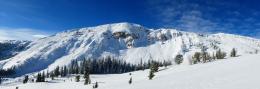
The mountains around Cooke City received 3” of snow with southwest wind gusting into the 30s. Weak layers of faceted crystals 1-2’ deep and another buried 3’ deep avalanched on many slopes after last week’s snowfall. A large avalanche on the Fin broke deeply on Saturday and over the weekend skiers noted many other avalanches on different aspects and elevations. If snowfall continues the danger will rise. With limited visibility, wind and snow, it is a good idea to avoid steep slopes. At the first sign of instability, such as cracking , collapsing or fresh avalanches, hightail it away from avalanche terrain. For today the avalanche danger is rated MODERATE, but could rise to CONSIDERABLE if 6+” fall during the day.
If you get out, please send us your observations no matter how brief. You can submit them via our website, email (mtavalanche@gmail.com), phone (406-587-6984), or Instagram (#gnfacobs).
King and Queen Fundraiser
February 6th and 7th -- AWESOME PRIZES for individuals who raise over $500! Two pairs of skis, Airbag Avy pack, and more! Deadline for fundraising is 1:15 p.m. Sunday, Feb. 7. No racing is necessary to compete for the fundraising prizes. Info is HERE.
Upcoming Avalanche Education and Events
See our education calendar for an up-to-date list of all local classes. Here are a few select upcoming events and opportunities to check out:
Every Saturday in Cooke City, FREE snowpack update and rescue practice at the Round Lake Warming Hut between 10 a.m. and 3 p.m. Poster with More Info.
February 5 and 6, Women's Companion Rescue Clinic with SheJumps. Registration HERE.
February 19 and 20, Companion Rescue Clinic. Registration HERE.
February 26 and 27, Women's Companion Rescue Clinic with SheJumps. Registration HERE.
On Saturday, January 30th a skier died in an avalanche in Utah outside the Park City Ski Area boundary. The search and recovery efforts were initially delayed due to dangerous avalanche conditions and were completed on January 31st. We are deeply saddened by this loss of life. Preliminary details are available here.