Good Morning. This is Dave Zinn with the Gallatin National Forest Avalanche Forecast on Tuesday, March 16th at 7:15 a.m. Today’s forecast is sponsored by Montana Chevy Dealers and Werner Wealth Management (Advisors with DA Davidson). This forecast does not apply to operating ski areas.
Mountain temperatures are in the upper teens to low-20s F with 5-10 mph winds from the north to west and there is no new snow. Highs today will be in the 30s F with 5-10 mph north to northeast winds and the next chance for precipitation is Friday night.

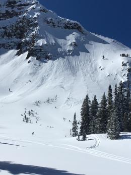
The last large slab avalanches that we know of in the mountains around Bozeman, Big Sky, and West Yellowstone occurred on the last day of February when two different groups triggered slides that broke on sugary depth hoar near the ground, taking out most of the year’s snowpack (weather and avalanche log). Since then, skiers and riders have observed small wet, loose snow avalanches on warm sunny days and relatively small wind slab avalanches in recently drifted snow. Yesterday, the Bridger Bowl Ski Patrol noted several natural wet snow avalanches coming out of steep east-facing terrain.
Wet snow avalanche activity is likely to be minimal today and wind slabs are stabilizing. Pay attention to wet, slushy snow deeper than a few inches as a sign of increasing danger this afternoon and to isolated areas where wind-drifted snow may still crack and slide. Small avalanches or cornice fall in technical terrain can be deadly, so stay vigilant with your assessments and safe travel protocols. Watch our recent videos from the field to review these avalanche concerns.
We are not forgetting about the weak snow near the ground. It will return to the forefront of the conversation when melt-water penetrates deep into the snowpack or if significant spring snowstorms arrive, but for now, triggering an avalanche on this layer is unlikely. The avalanche danger is LOW.
It may not have snowed in Cooke City as forecast, but at least it got windy. For several hours last night 15-25 mph wind transported the remaining soft snow into drifts that could crack and avalanche today. Wind-slabs are likely to be small and on isolated terrain features but could cause significant problems in high consequence terrain. Recent cornice collapses near Abiathar and Mount Fox remind us to minimize time spent under these overhanging masses of snow (details). Cooler temperatures and cloudy skies will limit warming today but keep wet, loose snow avalanches in mind if the sun pops out this afternoon. Generally safe avalanche conditions exist in Cooke City and the danger is LOW.
If you get out, please send us your observations no matter how brief. You can submit them via our website, email (mtavalanche@gmail.com), phone (406-587-6984), or Instagram (#gnfacobs).
Upcoming Avalanche Education and Events
See our education calendar for an up-to-date list of all local classes. Here are a few select upcoming events and opportunities to check out:
March 20, 5:30 p.m., Snowpack Update for Bozeman Splitfest, online Link to Join HERE
March 24, 6 p.m., Free 1-Hour Avalanche Awareness, online Link to Join HERE
March 29, 6 p.m., Free 1-Hour Avalanche Awareness, online Link to Join HERE
The University of Nevada, Reno School of Medicine and Montana State University are doing a brief survey to learn if and how the use of the winter backcountry has changed due to the coronavirus pandemic. The 5-minute survey is HERE.