Good Morning. This is Alex Marienthal with this season's final spring weather and snowpack update from the Gallatin National Forest Avalanche Center on Friday, April 30th. We have stopped issuing daily avalanche forecasts for the season.
This morning temperatures are 40s-50s F, wind is west-southwest at 15 mph with gusts of 20-30 mph and skies are partly cloudy. Today will be mostly sunny with temperatures reaching mid-60s F with west wind at 15-30 mph. Tomorrow will be ten degrees cooler with sunny skies turning to rain late afternoon.
On Sunday morning there is a chance for snow with temperatures dropping to low 30s to 40s F, and wind shifting to the north at 15-20 mph. Next week will start cloudy with light snow or rain, and temperatures in the high 20s to low 40s F. Minimal snow accumulation is expected until next weekend. The most will be on Sunday morning with possibly 1-2” south of Bozeman and 2-5” near Cooke City.

All Regions
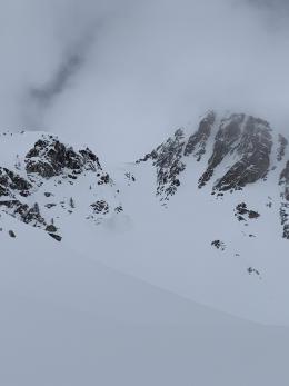
Large wet slab avalanches are likely today and tomorrow. Temperatures are the warmest that this winter’s snowpack has felt, reaching 40s and 50s F the last few days and not dropping below freezing the last two nights. We received a report from someone who traversed the Bridger Range on Wednesday and saw multiple wet slides, some that broke a couple feet deep (photos and details). As temperatures reach 60s F today, large wet snow avalanches will occur naturally, and will be easy to trigger if you travel on steep, snow-covered slopes. On Saturday afternoon, any steady rain in the mountains could trigger wet snow avalanches. Wet slides could remain possible to trigger on Sunday if the snowpack does not freeze Saturday night.
The weak, unconsolidated snowpack creates poor skiing and riding conditions and difficult travel. Don’t fight it, winter will return on Sunday. During these summer-like days while the deep, recently dry snowpack melts, consider off-snow activities or limit travel to low angle slopes. Get the bike out, maybe hit the river or crag. Regardless of your activity, minimize time spent underneath steep, snowy slopes even if the ground under your feet is dry.
Sunday and next week, conditions will be more appropriate for skis or a snowmobile. The snowpack will freeze most nights and avalanche concerns will involve new snow that falls, or small wet slides as the snow surface melts through each day. Avalanches will continue until the snowpack has melted. Remain diligent with careful snowpack assessment and cautious terrain selection. See below for additional general spring snowpack and travel advice.
Continue to share your avalanche observations. We will post them on our website/media to help each other stay safe. Thank you for your support and see you next fall. You can submit observations via our website, email (mtavalanche@gmail.com), phone (406-587-6984), or Instagram (#gnfacobs).
Give Big Gallatin Valley
Give Big Gallatin Valley is May 6th –7th. The Friends of the Avalanche Center are participating again this year and want to thank all of you for your support.
Announcements, Education and Events
Bridger Bowl is closed, and backcountry conditions exist (video). There is no avalanche mitigation or ski patrol rescue. Please stay clear of work areas, snowmobiles, chair lifts and other equipment.
GENERAL SPRING SNOWPACK AND TRAVEL ADVICE
Spring weather can be highly variable and create a mix of avalanche problems. Snow conditions and stability can change drastically from day to day or hour to hour. Anticipate rapid change and plan accordingly. Abundant snowfall over the winter with more spring snow to come makes avalanches possible into summer.
NEW SNOW AND WIND LOADED SLOPES
Spring storms are notorious for depositing heavy amounts of snow in the mountains. Even with a deep and generally stable snowpack throughout the advisory area, heavy and rapid loads of new snow will decrease stability. The main problems to look out for are avalanches breaking within the new snow, wind slabs, and loose snow avalanches. The likelihood of triggering an avalanche spikes during and immediately after snowstorms. New snow instabilities tend to stabilize quickly, but it’s a good idea to give fresh snow a day to adjust before hitting big terrain. New snow instabilities can be challenging to assess, and spring storms bond to old snow differently across aspects and elevations. Conservative terrain selection is essential during and immediately following storms. Avoid wind-loaded slopes and slopes steeper than 35 degrees for 24-48 hours after new snow and wind.
New snow can quickly change from dry to wet on a spring day, and stability can decrease rapidly with above freezing temperatures or brief sunshine. New snow may bond well early in the morning and then easily slide later. Wet loose slides are likely during the first above freezing temperatures or sunshine immediately after a storm. Anticipate changes in snow stability as you change aspect or elevation and over the course of the day. An early start is always an advantage. Be ready to change plans or move to safer terrain at the first signs of decreasing stability.
WET SNOW AVALANCHES
Spring and wet snow avalanches go hand-in-hand. Above freezing temperatures, rain, and/or intense sunshine cause the snow to become wet and weak and make wet avalanches easy to trigger or release naturally. Conditions tend to become most unstable when temperatures stay above freezing for multiple days and nights in a row. Avoid steep terrain, and be aware of the potential for natural wet avalanches in steep terrain above you, if you see:
- Heavy rain,
- Above freezing temperatures for more than 24 hours,
- Natural wet avalanches,
- Rollerballs or pinwheels indicating a moist or wet snow surface,
- Or if you sink to your boot top in wet snow.
In general, if the snow surface freezes solid overnight, the snowpack will be stable in the morning and stability will decrease through the day as snow warms up. The snow surface hardness, rate of warming, duration of sunshine, aspect and elevation determine how fast stability will decrease through the day. Be aware that sunny aspects may have a wet snow avalanche danger while shadier slopes still have a dry snow avalanche danger. Getting off of steep slopes should be considered when, or before, the above signs of instability are present. Wet snow avalanches, whether loose snow or slabs, can be powerful, destructive and very dangerous. Conservative terrain choices, starting early in the day, and careful observations can keep you safe. See Alex’s recent video, and this article for more spring travel advice.
CORNICES
Cornices along ridgelines are massive and can break under the weight of a person (photo). Prolonged above freezing temperatures and rain make them weaker and possible to break naturally. They can break off suddenly and farther back than one might expect. Cornice falls can also entrain large amounts of loose snow or trigger slab avalanches. Stay far back from the edge of ridgelines and minimize exposure to slopes directly below cornices. Regardless of whether a cornice triggers a slide or not, a falling cornice is dangerous to anyone in its path.
DISCLAIMER
It does not matter if new snow falls or not, avalanches will continue to occur until the existing snowpack is mostly gone. Always assess the slope you plan to ride with diligence and safety in mind. Do not let your guard down. Travel with a partner, carry rescue gear and only expose one person at a time in avalanche terrain.
Have a safe and enjoyable spring and summer!
Doug, Alex, Ian and Dave
For more spring travel advice see this article from our GNFAC forecaster blog.
Thank you to everyone that sent in observations, read the forecasts, took an avalanche class or donated money, time or gear. Our success is directly related to community support and the Forest Service. Have a safe spring and summer!