Good morning. This is Doug Chabot with the Gallatin National Forest Avalanche Forecast on Thursday, December 30th at 7:00 a.m. This information is sponsored by Blitz Motorsports and Yamaha and Cooke City Super 8/Bearclaw Bob’s. This forecast does not apply to operating ski areas.
AVALANCHE FATALITY
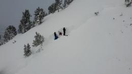
On Monday two snowmobilers were caught and killed in an avalanche on Scotch Bonnet Mountain, north of Cooke City. We posted a video of our accident investigation and will release a full report later this morning.
Since yesterday morning the mountains around Bozeman and Big Sky got 1-2” while the higher elevations outside West Yellowstone and Cooke City received 3-4”. Wind increased last night from the west to southwest averaging 25 mph with gusts reaching 48 mph. These strong winds will continue today before tapering tonight. At 5 a.m. temperatures are in the single digits and will warm into the teens. Today will be snowy and by morning 2-3” will fall around Bozeman and Big Sky with 3-5” in the southern ranges including Cooke City.

It snowed more than 4 feet (4.3” snow water equivalent) in the last 8 days in the southern mountains including Cooke City (weather log). Yesterday’s 4” of new snow coupled with strong wind and more snow today is making dangerous avalanche conditions on wind-loaded slopes. On Monday two snowmobilers were killed on one of these slopes and these are not any safer today (incident). Other avalanches in Cooke City (photo1, photo2) and “one monster whumph” in Bacon Rind are signs that instability continues. A whumpf is the sound of a weak layer breaking and propagating under you. It is an avalanche on flat terrain and a sign of instability. Avoid avalanche terrain that has been wind-loaded. Slopes without a wind load still harbor a weak layer of faceted, sugary snow that is propagating in stability tests. Dig and investigate slopes before blindly committing to avalanche terrain. For today, the danger is rated CONSIDERABLE on wind-loaded slopes and MODERATE on all others.

Dave gets a gold star for “walking the talk”. We preach hunting for instability even when things seem safe. Yesterday, Dave and his partner toured into the northern Bridger Range with an expectation of finding stable snow. It did not turn out that way. He dug his first pit low on a slope and surprisingly found a weak layer breaking clean. He dug 5 more pits and got breaks on some more. A thin layer of weak, faceted crystals (called near-surface facets) was in the middle of the 2-3 foot deep snowpack. He did not get into avalanche terrain. Instead, he made a video explaining why. Other skiers found this layer too. Given the discovery of this new weak layer and potential for triggering avalanches on it we recommend digging and avoiding avalanche terrain if you find it. Additionally, strong west wind is building shallow drifts that could be triggered. For today the avalanche danger is rated MODERATE on all slopes.
Strong west wind is blowing in the northern Madison and northern Gallatin Ranges. Two inches of new snow and a few more today will be blown into drifts. These will be found near the ridgelines and in gullies and I anticipate a person could trigger a few wind slabs. On slopes without a wind load the stability is good. Although there is weak, faceted snow near the ground it is currently not a problem. In the last week we’ve either visited or had reports from Mt Ellis, Mt Wheeler, Lick Creek, Mt Blackmore, Beehive Basin (video) and Buck Ridge (video) where generally stable conditions exist.
For today, it remains possible to trigger slides on wind-loaded slopes which have a MODERATE danger. On all other slopes avalanches are unlikely and the danger is rated LOW.
If you get out, please send us your observations no matter how brief. You can submit them via our website, email (mtavalanche@gmail.com), phone (406-587-6984), or Instagram (#gnfacobs).
Upcoming Education Opportunities
Get your avalanche brain ready for the season at one of the many classes listed on our education calendar, and list of upcoming events below.
January 20 + Field day. Our popular Avalanche Fundamentals with Field Course is perfect as a refresher or an introduction to avalanches. We are introducing a new format with four pete-recorded lectures to watch at your convenience, a live question and answer session, and a choice of a snowmobile or ski/ board based field day occurring the following two weekends.
Every Saturday near Cooke City, 10 a.m.-3 p.m. FREE snowpack update and transceiver/rescue training. Stop by for 20 minutes or more at the Round Lake Warming Hut.
On Monday, December 27th, two snowmobilers were caught and killed in an avalanche on Scotch Bonnet Mountain, north of Cooke City. We investigated the scene on Tuesday and made a video about what happened.