Good morning. This is Ian Hoyer with the Gallatin National Forest Avalanche Forecast on Friday, January 28th at 7:00 a.m. This information is sponsored by Yellowstone Club Community Foundation and Montana State Parks. This forecast does not apply to operating ski areas.
There is no new snow to report. West winds are blowing 20-25 mph gusting to 40 mph around Bozeman and 10-15 mph elsewhere. Mountain temperatures are in teens F this morning. Today will be mostly sunny with high temperatures in the 20s and 30s F. Winds will be 10-20 mph out of the west. No snow is forecast through the weekend.

All Regions
Large avalanches are unlikely today. That does not mean it is impossible to trigger a slide, so stick with good travel practices and be on the lookout for signs of instability. Only expose one person at a time to steep slopes. Watch your partners from a safe spot. And everyone in the group needs to be carrying rescue gear.
If you’re stepping out into more consequential and exposed terrain, be ready to back off a slope if you find signs of instability such as cracking or poor snowpack test results. Skiers yesterday in the Northern Madison Range triggered two very small “micro” wind slabs and took heed of that warning by changing plans and backing off the steep and exposed slopes they were headed for. Thin wind slabs are the hazard you’re most likely to encounter, but even these will mostly be well bonded and triggering one is generally unlikely. Yesterday, Alex and Doug investigated a thin slide on Saddle Peak that avalanched a few days ago (video, details). It broke 6-8” deep and 1000ft wide on a thin layer of facets under a hard wind slab. It is worth quickly searching for and testing weak layers in the upper snowpack to avoid being surprised. Many slopes have these weak layers (either near surface facets or surface hoar), but for now they’re only a problem where they’re hiding under thin wind slabs.
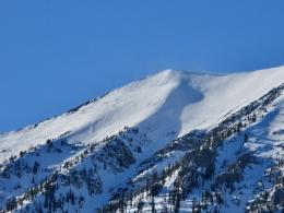
On Mt. Ellis yesterday, I found a thin snowpack that has gotten weaker over the last month (video). Without a stiff slab the snowpack there is currently just weak but not unstable. It’s worth filing that info away because it’ll become problematic when it starts snowing again.
Throughout our forecast area the avalanche danger is rated LOW.
If you get out, please send us your observations no matter how brief. You can submit them via our website, email (mtavalanche@gmail.com), phone (406-587-6984), or Instagram (#gnfacobs).
Upcoming Education Opportunities
See our education calendar for an up-to-date list of all local classes. Here are a few select upcoming events and opportunities to check out:
February 4th, Dillon Montana Avalanche Fundamentals, three-part series of pre-recorded lectures, virtual Q&A and an in-person field session. Pre-registration and more information HERE.
February 5th, King and Queen of the Ridge at Bridger Bowl. Come hike and ski with your friends for avalanche awareness and fun! Details below.
Every Saturday near Cooke City, 10 a.m.-3 p.m. FREE snowpack update and transceiver/rescue training. Stop by for 20 minutes or more at the Round Lake Warming Hut.
KING AND QUEEN OF THE RIDGE, FEBRUARY 5TH
Do you like to hike? Do you like to ski? Then the King & Queen of the Ridge is for you. Hike, ski and raise money for the Friends of the Avalanche Center in their 2nd biggest fundraiser of the year. Join the effort to promote and support avalanche safety and awareness! Fundraising prizes for top 5 individuals who raise over $500. No racing is necessary to compete for the fundraising prizes. Info is HERE. Race participants for the February 5th event must register separately with Bridger Bowl HERE.
The Beacon Park at Beall Park in Bozeman and the West Yellowstone Beacon Park are up and running! Stop by to check them out and practice with your rescue gear.