This is Doug Chabot with pre-season avalanche, weather and event information from the Gallatin National Forest Avalanche Center on Sunday, November 20th. Our next update will be Wednesday. This information is sponsored by The Friends of the Avalanche Center and Grizzly Outfitters.
*Note: Bridger Bowl Ski Area is closed and there is no avalanche control or ski patrol services. Backcountry conditions exist. Please don’t ski over hoses and power cords, they are high-pressure and high-voltage. Be sure to give snowcats and snowmobiles plenty of room.
On Sunday morning, skies are clear, temperatures are 10-20F and wind is 15-25 mph from the southwest to northwest. There’s no new snow to report and we don’t expect any until maybe Wednesday. High pressure dominates and wind will be light with mountain temperatures settling into the high 20s.

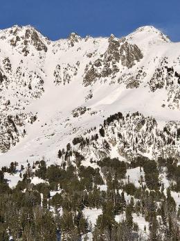
Last week snowfall was followed by wind. Consequently, skiers reported wind slab avalanches in our northern areas on Thursday, Friday and Saturday (avalanche list). The most consequential was yesterday in Beehive Basin when skiers narrowly missed getting hit by a natural avalanche of wind-blown snow (7-sec video). Seeing natural avalanches roar past is thankfully a rare occurrence. This near-miss is all the evidence we need to know that wind-drifts are ready to break. I do not expect many natural slides, but skier or sledder triggered avalanches are on the menu the next few days.
Be on the lookout for densely packed wind drifted snow. Shooting cracks are a sign the snow wants to avalanche. If you are planning on getting into avalanche terrain, make sure you do your homework and dig and test. We have a layered snowpack, avalanche activity and propagating cracks to contend with. Carry rescue gear, go with a partner and only travel one at a time in avalanche terrain; timeless advice for anyone who plays on snow covered slopes.
Thank you for sending in your observations. They are all listed on the Snow Observations Page and contribute to our understanding of this season’s snowpack by submitting your observations.
Ian will update this information on Wednesday morning. If you get out, please share avalanche, snowpack or weather observations via our website, email (mtavalanche@gmail.com), phone (406-587-6984), or Instagram (#gnfacobs).
The Island Park area has about 4 feet of snow on the ground (Sawtelle Peak video). Wind the last few days has likely drifted snow that could avalanche. Shooting cracks are a sign the snow wants to avalanche. If you are planning on getting into avalanche terrain, make sure you do your homework and dig and test the shallow snowpack.
Upcoming Avalanche Education and Events
Our education calendar is full of awareness lectures and field courses. Check it out: Events and Education Calendar.
We are offering an Avalanche Fundamentals with Field Session course for skiers in December and January, and snowmobilers in early January. Sign up early before they fill up.
The Friends of the Avalanche Center are hosting the Powder Blast Fundraiser. Your donations support free and low-cost avalanche education, beacon checkers at trailheads, beacon parks, weather stations, and GNFAC programs! The Friends of GNFAC launched an online GoFundMe campaign. Please consider a donation, and we look forward to having an in-person event again in the future.