Good morning. This is Doug Chabot with the Gallatin National Forest Avalanche Forecast on Wednesday, December 14th at 7:00 a.m. This information is sponsored by Beartooth Powder Guides, Cooke City Motorsports and Gallatin Valley Snowmobile Association. This forecast does not apply to operating ski areas.
Please consider donating to the Friends of GNFAC Annual Fundraiser.
Yesterday morning a trace to 1” of snow fell. Winds have calmed from the west to north at 5-15 mph, but in the Bridger Range it is blowing west at 25-39 mph. Mountain temperatures are in the single digits F this morning and will warm to the teens. Today will be snowy with 2-4” in the northern mountains and 1-2” in the southern ranges by tomorrow morning. Ridgetop wind will blow 20-30 mph from the west to north during the storm.

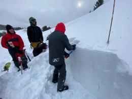
In the mountains south of Big Sky to West Yellowstone and Cooke City we are finding weak snow that is buried 2-3 feet deep. These sugary, faceted grains are capped with a stiff wind drift and are showing signs of instability. Alex was surprised by unstable snow in Cooke City (observation) on Friday, and yesterday in Lionhead both Dave and I, along with Ian in Bacon Rind, and a skier on Kirkwood Ridge (observation), had collapses (whumpfs), which are essentially avalanches on flatter ground. This was our primary sign that slopes harbored instability. As Ian pointed out in his video, there’s no need to dig snowpits searching for instability when whumpfs are felt (video).
A poor snow structure of thicker, meatier slabs of snow being supported by a weak layer plagues the southern mountains. Our snowpits illustrate this and we found it again yesterday in Lionhead (video). Since natural avalanches are unlikely and triggering them is thankfully not guaranteed, we can still get out and have fun on shallow angled slopes. Whumpfs and poor test scores tell us we need to travel with caution. Yesterday, we chose not to get on steep slopes and carefully crossed runout zones one at a time. For today, avalanches remain possible and the danger is rated MODERATE.
Wind-drifted slopes remain a concern in the mountains around Bozeman and Big Sky. Avalanche activity on Saturday in the northern mountains illustrate a lingering problem. On Sunday, Alex and his partner found thick wind drifts perched atop weaker snow on Saddle Peak (video). This structure is reminiscent of years past when we had large avalanches later in the season. It was also similar to the instability I found in the gullies up Hyalite (video). On Buck Ridge a group of sledders also found weak snow under wind slabs (observation).
Dave went to Mount Ellis on Monday and found relatively stable snow on his tour (video). No matter where you head to, it’s a good idea to test the slope you want to play on. Dig a pit, look for instability and back off if you find it. We have a recent history of avalanches and we are still finding buried weak layers breaking in our stability tests. Consequently, the danger is rated MODERATE.
If you get out, please share avalanche, snowpack or weather observations via our website, email (mtavalanche@gmail.com), phone (406-587-6984), or Instagram (#gnfacobs).

We are finding weak snow that is buried 2-3 feet deep. These sugary, faceted grains are capped with a stiff wind drift and are showing signs of instability. Since natural avalanches are unlikely and triggering them is thankfully not guaranteed, we can still get out and have fun on shallow-angled slopes. Whumpfs and poor test scores tell us we need to travel with caution. Yesterday, we chose not to get on steep slopes and carefully crossed runout zones one at a time. Check out Friday’s Yale Creek Drainage field video for more specific information.
Submit your snow, avalanche and weather observations to contribute to the Island Park Trip Planning page.
Upcoming Avalanche Education and Events
Our education calendar is full of awareness lectures and field courses. Check it out: Events and Education Calendar.
TOMORROW, Thursday, December 15, 6:30 p.m., 1-Hour Avalanche Awareness at Uphill Pursuits. Free.
Saturday, December 17, 10 a.m., Avalanche Awareness - Winter Wonderland at Montana Science Center. More information HERE.
Monday, December 19, 5:30 p.m., Women in the Backcountry at MAP Brewing. Free.
Every Saturday, 10 a.m - 2:00 p.m. Avalanche Rescue Training, drop in for any amount of time. Round Lake Warming Hut, Cooke City. Free.
Send us your observations. They do not have to be fancy, just a few sentences. Did you see any avalanches? How much new snow? Is the wind blowing and drifting snow? Pictures, snowpits and stability test scores are also welcome, but not necessary. You can help us fill in the gaps of our field work.