Good morning. This is Dave Zinn with the Gallatin National Forest Avalanche Forecast on Tuesday, March 14th at 7:00 a.m. This information is sponsored by Montana State Parks and Yellowstone Club Community Foundation. This forecast does not apply to operating ski areas.
AVALANCHE WARNING
The Gallatin National Forest Avalanche Center is issuing a backcountry avalanche warning for the Centennial Mountains. Heavy snow and strong winds are creating very dangerous avalanche conditions. The danger is HIGH on all slopes. Human-triggered and natural avalanches are likely. Backcountry travelers should stay off of steep slopes and stay away from the bottom of steep slopes. Avalanches can be triggered from flat terrain. Steep slopes can avalanche far above and run into lower-angled terrain.
This warning will expire or be renewed by 6 AM, March 15, 2023.
This morning, there is 4-6” of snow from the Taylor Fork south through West Yellowstone and Cooke City, 3” in the Big Sky area, and an inch in the Bridger Range. Temperatures are in the 20s F with 20-40 mph winds from the west to the south (15-20 mph - Bridger Range). Today, temperatures will be in the 30s F, and 25-35 mph winds from the south to southwest will slow later in the day. With West Yellowstone getting the most, the southern ranges will receive 8-14” of snow by morning, with 3-4” near Big Sky and 1-3” near Bozeman.

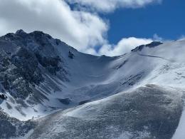
The mountains around West Yellowstone and Cooke City received 4-6” of new snow, and the wind is averaging 25-30 mph from the southwest. During the day, the mountain will receive an additional 6-8” of snow.
During the last significant pulse of snow at the end of last week, avalanches broke naturally up to 1000’ wide and 4-6’ deep on many slopes at Lionhead Ridge (photos and details). In Cooke City, natural and human-triggered avalanches were large and plentiful. Alex made a video describing some of these slides. Others submitted observations describing snapping trees and powder clouds coming from a human-triggered avalanche on Scotch Bonnet (observation and photo) and a 2000’ wide and 4-6’ deep avalanche near Abundance Lake (photos and details).
Snow will continue throughout the day, and we expect to get reports of more large avalanches. Avoid high-elevation terrain that is likely wind-loaded and the runout zones below where natural and human-triggered avalanches are likely. The avalanche danger is HIGH on wind-loaded slopes and CONSIDERABLE on all others.

The Southern Gallatin and Southern Madison Ranges received 3-4” of new snow and the wind is gusting to 40 mph from the southwest. Snow will continue, with 4-8” possible by this evening. Avoid wind-loaded slopes where human-triggered avalanches are likely. This includes most high-elevation slopes exposed to significant wind, areas below cornices, and slopes where you feel the snow surface stiffen or crack. Avalanches will most likely consist of the recent snow, breaking 1-2’ deep. However, a recent history of large natural avalanches, including one on Red Mountain that broke up to 15’ deep (photos and observation), one over 1000’ wide on Electric Peak (photos and observation) and two monsters in Tepee Basin (photos and observation), show the potential for large avalanches breaking multiple feet deep and over 1000’ wide.
Seek out terrain sheltered from the wind where a good snowpack assessment and safe travel protocols are strongly advisable or stay on slopes less than 30 degrees steep. The danger is CONSIDERABLE on wind-loaded slopes and MODERATE on all others.

A trace to 3” of snow fell in the mountains around Bozeman and Big Sky, with a few more expected today. Strong winds gusting to 70 mph in Big Sky and Hyalite Canyon are blowing snow at all elevations. Yesterday in Beehive Basin, I outlined our concerns about wind-loaded slopes and deep slab avalanches (video).
When deep slab avalanches like the one I investigated on Hyalite Peak last week and one in the Bridger Range this weekend (photos and observation) are on the table, follow a conservative travel plan. Choose sheltered terrain on slopes with fewer complicating factors like rock, cliffs and walls of trees that increase the consequences of a mistake. Evaluate the snowpack for instability and follow safe travel protocols. The avalanche danger is rated MODERATE.
Please share avalanche, snowpack or weather observations via our website, email (mtavalanche@gmail.com), phone (406-587-6984), or Instagram (#gnfacobs).
Avalanche Warning
The Gallatin National Forest Avalanche Center is issuing a backcountry avalanche warning for the Centennial Mountains. Very dangerous avalanche conditions exist. Human-triggered and natural avalanches are likely on all steep slopes. The mountains received 14” of new snow, and the wind is blowing 30-45 mph from the southwest. During the day, Island Park could see an additional 12” of snow.
Backcountry travelers should stay off steep slopes and away from the bottom of steep slopes. Avalanches can be triggered from flat terrain. Steep slopes can avalanche far above and run into lower-angled terrain. Traveling in and below steep is not recommended.
Upcoming Avalanche Education and Events
Our education calendar is full of awareness lectures and field courses. Check it out: Events and Education Calendar.
Saturday, 10 a.m. - 2:00 p.m. Avalanche Rescue Training, drop in for any amount of time. Round Lake Warming Hut, Cooke City. Free.
Loss in the Outdoors is a support group for those affected by grief and loss related to outdoor pursuits. Check out the link for more information.
A list of all avalanche activity from our forecast area is available HERE.