Good morning. This is Dave Zinn with the Gallatin National Forest Avalanche Forecast on Tuesday, March 26th at 7:00 a.m. Today’s forecast is sponsored by Alpine Yamaha in Livingston and the Yellowstone Club Community Foundation. This forecast does not apply to operating ski areas.
Mountain temperatures are in the single digits to teens F this morning, with 5-15 mph winds from the west to northwest. The mountains around Bozeman and Big Sky received 2-4” of new snow in the last 24 hours, with 0-1” across the rest of the advisory area. Today, high temperatures will be in the 20s to low 30s F, with 5-15 mph winds from the west to northwest. The mountains around Bozeman and Big Sky will get 2-4” of snow by tomorrow morning, with 1-2” near West Yellowstone, Island Park and Cooke City.

All Regions
Three-day snow totals are creeping up and incrementally loading a snowpack that has repeatedly demonstrated an inability to handle much weight without breaking. Since Saturday, snow in the mountains around Bozeman, Big Sky and Island Park totaled 7-11", equal to 0.6-0.9” of snow water equivalent (SWE) (Big Sky is the winner). There is less new snow in the mountains near Cooke City and West Yellowstone, totaling around 4”, equal to 0.4-0.5” of SWE. While we don’t expect a widespread cycle of deep, tree-snapping slides with current snow loads, more snow is forecast today, and a large avalanche breaking deep in the snowpack should not be shocking. Avalanches within the new and wind-drifted snow are more likely and will be large enough to bury or injure skiers and riders, especially in the presence of terrain traps such as trees, cliffs, gullies, and rocks.
Deep avalanches failing on persistent weak layers will result from one of two scenarios. First, a natural or human-triggered wind-slab avalanche or cornice fall could trigger a deeper slide. Second, a backcountry traveler could get unlucky and cross a thinner area in the snowpack, triggering the whole slope. Regardless of how the avalanche initiates, getting caught in a slide breaking 3-6 feet deep and hundreds of feet wide is more easily fatal than not. The last avalanche of this sort occurred seven days ago on Mount Blackmore and resulted in a helicopter evacuation by Gallatin County Search and Rescue (details). Accurately testing for deep slab instability with a snowpit is difficult to impossible. Regional observation over the course of a storm is the best proxy for understanding what is possible at the slope scale (avalanche activity list). Conservative terrain selection is the right course of action while the snowpack is getting loaded.
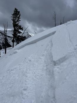
Slab avalanches breaking 6-18” deep within the new and wind-drifted snow are more likely. These instabilities often appear in snowpits or with signs such as recent avalanche activity or shooting cracks. Yesterday, a snowboarder in Cooke City intentionally triggered a wind-loaded slope that broke 10” deep and 30 feet wide (photo and details). On Sunday, Alex saw two natural avalanches within the wind-drifted snow and intentionally triggered a small slide on a test slope (video). Avoid large, wind-loaded slopes and cornices.
If you are considering traveling in avalanche terrain today, choose simpler, less steep slopes sheltered from the wind and without terrain traps. The danger is rated MODERATE.
If you get out please submit an observation. It does not need to be technical. Did you see any avalanches? How much snow is on the ground? Was the wind moving snow? Simple observations are incredibly valuable. You can also contact us by email (mtavalanche@gmail.com), phone (406-587-6984), or Instagram (#gnfacobs).
Upcoming Avalanche Education and Events
Our education calendar is full of awareness lectures and field courses. Check it out: Events and Education Calendar.
Loss in the Outdoors is a support group for those affected by loss and grief related to outdoor pursuits. Check out the link for more information.
If you have a few minutes, take a survey on how you interpreting avalanche forecast information in hopes of improving avalanche forecasting methods.