Good Morning. This is Alex Marienthal with the Gallatin National Forest Avalanche Advisory issued on Monday, February 5th at 7:00 a.m. Today’s advisory is sponsored by Grizzly Outfitters in partnership with The Friends of the Avalanche Center. This advisory does not apply to operating ski areas.
AVALANCHE WARNING
The Gallatin National Forest Avalanche Center is issuing a Backcountry Avalanche Warning for the mountains near Cooke City. More than 3 feet of heavy snow since Friday and strong winds create dangerous avalanche conditions. The avalanche danger is rated HIGH on all slopes. Natural and human triggered avalanches are likely. Avalanche terrain and avalanche runout zones should be avoided.
This warning will either expire or be updated by 6:00 a.m. on February 6, 2018.
Since yesterday morning, 10-12” of dense new snow fell in the mountains near Cooke City and the northern Bridger Range. Near Bridger Bowl and Hyalite got 1-2” of new snow, and near Big Sky and West Yellowstone got 2-4”. Temperatures are currently high teens to 20s F. Wind overnight was westerly at 20-30 mph with gusts of 50-60 mph. Today, temperatures will be in the 20s F with westerly wind at 20-30 mph. Snow showers will continue through tonight with 4-6” in the mountains by tomorrow morning.
Avalanche Warning
Since Friday, the mountains near Cooke City got over 3 feet of snow equal to 3.3” of snow water equivalent (SWE). Strong westerly wind drifted this snow into slabs at least 2-4’ deep, which will avalanche naturally. These avalanches can run far into flat terrain and have the power to break large trees. Large, destructive avalanches were observed last week (video, photo), and on Saturday a skier triggered an 18” deep, 150’ wide avalanche on a low angle, wind loaded slope (photo). Similar or larger slides are likely today. Avoid steep slopes and flat runout zones below, especially underneath heavily wind loaded slopes. Find safe riding on low angle slopes sheltered from the wind and not exposed to steep, wind-loaded terrain above. Large natural avalanches are likely today and the avalanche danger is HIGH on all slopes.

The northern Bridger Range has up to a foot of new snow equal to 1.1” SWE, though only 1-2” of new snow fell near Bridger Bowl. Avalanches are possible where dense new snow is deeper than 6-8”. On wind loaded slopes, slabs 1-3’ deep are likely and could avalanche naturally. More snow and wind today will increase the size and distribution and of these slabs. Avoid steep, wind loaded slopes and be extra cautious of all steep terrain where new snow is deeper than 6-8”. Avalanche danger is CONSIDERABLE on wind loaded slopes and MODERATE on non-wind loaded slopes.

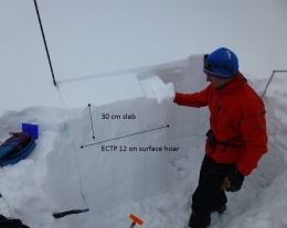
The mountains near West Yellowstone and the southern Madison and Gallatin ranges got 3-4” of new snow equal to .5” of SWE. Strong westerly wind drifted recent snow into slabs up to a foot thick that are possible to trigger along ridgelines, cross-loaded terrain features, and the bottom of cliffs. Doug and I skied near Hebgen Lake yesterday, and our snowpack tests showed avalanches are possible on a layer of surface hoar buried 1-2’ deep, or on weak facets near the ground (video). The surface hoar is not on every slope, and facets near the ground are difficult to trigger. Dig a hole to assess these layers before riding steep slopes. Today, avalanches are possible and avalanche danger is MODERATE.
The mountains near Big Sky and Hyalite got 2-3” of new snow overnight and 7-10” since Friday. Strong winds drifted this snow into fresh slabs that are possible to trigger. Over the weekend, skiers in Hyalite, Beehive, and the northern Bridger Range reported small natural and skier triggered wind slabs. Be cautious of wind loaded slopes near ridgelines and at the base of cliffs. Avoid riding above cliffs, dense trees, or other terrain traps to minimize consequences if caught in a slide. On non-wind loaded slopes the snowpack is generally stable (video). Avalanche danger is MODERATE on wind loaded slopes and LOW on non-wind loaded slopes.
If you get out and have any avalanche or snowpack observations to share, drop a line via our website, email (mtavalanche@gmail.com), phone (406-587-6984), or Instagram (#gnfacobs).
Upcoming Avalanche Education and Events
BOZEMAN
Feb. 6th, Sidecountry specific avalanche awareness for family and friends. 6-8 p.m. @ Beall Park
Feb. 7th, Woman’s specific avalanche awareness, 6-7:30 p.m. @ REI in Bozeman
Feb. 7th, Avalanche awareness, 6-7:00 p.m. @ Roskie Hall MSU
Feb. 9 and 10, Companion Rescue Clinic, Info and Register
Feb. 28th, Know Before You Go avalanche awareness, 7:00 p.m. @ Procrastinator Theater, MSU
March 2nd, Avalanche Awareness, 6-7:00 p.m. Bozeman Split Fest
March 7th, Avalanche Awareness, 6-7:30 p.m. @ REI
PHILLIPSBURG
Feb. 8th, Avalanche Awareness, 6:30-8:30 p.m. @ the new Fire Hall
DILLON
Feb. 24th and 25th, Snowmobile intro to avalanches w/ field course. More info: https://msuextension.org/conference/.
WEST YELLOWSTONE
Feb. 10th, Avalanche Awareness, 7-8 p.m. at West Yellowstone Holiday Inn Conference Center
COOKE CITY
Every Friday and Saturday, Current Conditions Update and Avalanche Rescue, Friday 6:30-7:30 p.m. at The Soda Butte Lodge in February. Saturday anytime between 10-2 @ Round Lake.
In Dashboard Talk: Episode 5 Doug and Eric discuss being safe while gathering snow stability data.