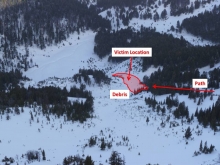
Advisory Archive
Yesterday morning another one to two inches fell in most ranges, but snow showers outside West Yellowstone dropped five inches of new snow. Winds are increasing out of the west to southwest and are currently blowing 20-35 mph with temperatures in the single digits. A storm is slated to arrive early this afternoon and last into Thursday. In the next 24 hours I expect six to eight inches of new snow in the mountains with strong westerly winds and temperatures only rising into the high teens before dropping to the low single digits tonight.


A surprise storm has hammered the Bridger Range, depositing 14” of cold smoke powder over the past 24 hours, and it’s still snowing! Cooke City is the runner up receiving 6-8 inches over the past 24 hours while the mountains around West Yellowstone and Big Sky including the northern Gallatin Range have picked up 3-4 inches. Ridgetop winds are strongest in the Bridger Range blowing 30-40 mph out of the W; the rest of our advisory area is receiving winds out of the WNW at 15-30 mph. Temperatures are ranging from the single digits in the north to the low teens in the south. Today, winds will continue to blow 15-30 mph shifting to the WSW and temperatures will climb into the 20’s. Snow will likely taper off by early afternoon and skies will become partly to mostly cloudy. No major accumulations are expected over the next 24 hours.
A closed Low over Wyoming has produced east winds throughout our advisory area limiting snow accumulations. Over the past 24 hours, 3-4 inches of low density snow has fallen in the southern ranges while a Tr-1” has fallen in the north. Temperatures are much colder in the mountains around Bozeman with Bridger Bowl recording the lowest temperature of -7 F. Conditions warm steadily farther south. West Yellowstone is the warm spot at 21 F while the mountains around Big Sky and Cooke City are recording temps around 10 F. Currently, winds are blowing out of the SSE at 5-15 mph and should gradually switch to more westerly flow by this afternoon. Today, temperatures will struggle into the single digits in the north and low 20s in the south. Another 2-3 inches will fall in the mountains around West Yellowstone and Cooke City while the north will pick up an inch or two.
Over the past 24 hours, a moist SW flow has deposited 4-6 inches of snow in the mountains around Cooke City and West Yellowstone. The mountains around Big Sky including the northern Gallatin Range have picked up 2-3 inches while the Bridger Range has remained dry. Most areas are still receiving strong winds which are blowing 15-40 mph from the SSW, with the exception of the Bridger Range where winds have calmed to 5-10 mph. Temperatures are in the teens and will warm into the mid 20’s by this afternoon. Skies will stay cloudy today and winds will continue to blow out of the SW at 15-30 mph as another storm system approaches our area. The southern mountains will likely see accumulations of 4-6 inches by tomorrow morning while the northern mountains will pick up 2-4 inches.

Since yesterday morning the mountains near Cooke City and West Yellowstone received an additional 1-2 inches of snow. Most areas received strong winds which were blowing 15-45 mph from the SSW this morning except in the Bridger Range where winds calmed overnight and were blowing 10-15 mph. Temperatures were in the low teens and high single digits F this morning. A moist SW flow will bring more snow by tomorrow morning with the southern parts of the advisory area receiving 2-3 inches and a trace to 1 inch further north. Today temperatures will be in the upper teens and low 20s F. Winds should decrease slightly and blow 10-30 mph.
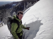
Overnight 7-10 inches of snow fell throughout the advisory area with right side up snow (warm and dense snow with cold light snow on top). The storm started warm with temperatures near 30 degrees F dropping to the low teens and single digits F this morning. Ridgetop winds throughout the storm and into this morning were blowing 20-40 mph from the SW. Cold air advection will prevent temperatures from rising today. Winds should decrease somewhat and blow 20-25 mph from the SW. Although the heaviest snow has ended, more will come today and tonight producing another 4-6 inches. An unsettled weather pattern for the next few days will not bring any major storms but generally cool and snowy weather.
West winds picked up again yesterday and averaged 30-40 mph with gusts hitting 60-80 mph as temperatures reached the high thirties before falling to the low twenties last night. Currently west-southwest winds are blowing 20-40, except around Cooke City where they are 30-60 mph. Today, expect increasing clouds from a moist, southwest flow and snowfall later this afternoon lasting into tomorrow. Cooke City is poised to get the brunt of the storm. By morning the southern mountains could have 8-10 inches of new snow with half that amount falling in the northern areas.

Yesterday was gorgeous with sunny skies, mountain temperatures in the mid thirties and westerly winds at 20-30 mph. Today will start out sunny, but clouds will roll in late this afternoon. Mountain temperatures will reach 40F in the mountains from the high 20s this morning. Winds increased overnight and are currently blowing west to southwest at 30 mph with gusts reaching 50 mph. Wind, warmth and sun will hopefully give way to cold, clouds and snow sometime tomorrow. The mountains could use a facelift.

Southwest Montana will receive a welcomed reprieve from the wind today as a ridge of high pressure builds over the region. Currently, winds are blowing out of the WSW at 15-30 mph and will continue at these speeds for the remainder of the day. Mountain temperatures are presently in the mid to high 20s and will rise into the 40s under mostly sunny skies. Another round of wind is expected to arrive tomorrow.
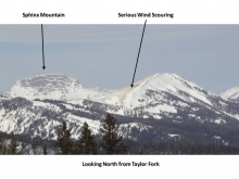
Freight train winds have been the main weather event over the past 24 hours. Currently, winds are cranking out of the WSW at 30-40 mph with gusts reaching over 50 mph in most mountain locations. Temperatures are in the mid 20s to low 30s F and will rise into the 40s by this afternoon. Skies will be partly cloudy today and winds will gradually decrease by this evening.