Good morning. This is Ian Hoyer with the Gallatin National Forest Avalanche Forecast issued on Tuesday, March 5th at 7:00 a.m. Today’s forecast is sponsored by Yellowstone Arctic Yamaha in partnership with the Friends of the Avalanche Center. This advisory does not apply to operating ski areas.
This morning there is no new snow and mountain temperatures are in the single digits above and below zero F. An inversion has valley temperatures in the negative teens F. Winds have been light, out of the south in the southern ranges and west-northwest in the northern ranges and Cooke City. Today temperatures will reach the high teens and low twenties F, and winds will be southwest-west at 5-15 mph. Snow tonight will bring 1-3” by tomorrow morning.

All Regions
Under clear skies, stability is improving across the advisory area. Riding in the Lionhead area yesterday I was pleasantly surprised by how well the snowpack has accommodated the huge load of snow that fell during the storm last week (video). The weak layers near the ground are gaining strength and instabilities in the new snow are settling out. Still, we can’t forget that it has only been four days since we last issued an avalanche warning. There are a variety of avalanche concerns which require continued vigilance as you travel through the mountains today.
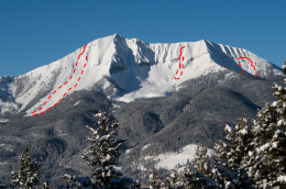
Numerous large avalanches broke during last week’s storm across the whole advisory area. See our avalanche activity page for a comprehensive list. Of particular note is that snow safety directors at Big Sky, Bridger Bowl and the Yellowstone Club each reported avalanches breaking as large as they have ever seen in particular paths, including a large natural avalanche on the west side of Saddle Peak in the backcountry near Bridger Bowl, a large natural slide on Wilson Peak near Big Sky, and an explosive triggered avalanche by the Yellowstone Club ski patrol. If you find the wrong spot, you can still trigger one of these huge slides today. Slopes to avoid include those that got the biggest load (heavily wind loaded slopes) and those where you can most easily impact the weak layers (slopes with less than five feet of snow or variable snow depth) (video, photo).
Avalanches can also break 1-3’ deep in recently formed wind drifts. If the surface snow is stiff and cracking in front of your skis or sled, move to a lower angled slope, or one that hasn’t been wind affected.
Although it hasn’t felt like it during this cold snap, spring is upon us. Watch for the snow surface becoming wet on sunny slopes this afternoon. Loose snow avalanches (photo) and cornice falls (photo) are both possibilities.
With a variety of concerns today, the avalanche danger is MODERATE.
If you get out and have any avalanche or snowpack observations to share, contact us via our website, email (mtavalanche@gmail.com), phone (406-587-6984), or Instagram (#gnfacobs).
Avalanche Fatality in Colorado
On Sunday, a solo backcountry skier was caught, buried, and killed in an avalanche near Telluride, Colorado. You can read the preliminary report here.
Upcoming Avalanche Education and Events
Our education calendar is full of awareness lectures and field courses. Check it out: Events and Education Calendar.
BOZEMAN
March 6, 1-hr Avalanche Awareness, 6-7 p.m. at REI Bozeman.
March 6, Drinks for a Purpose, 5-8 p.m. at Bozeman Spirits Distillery, More info.
COOKE CITY
Every Friday and Saturday, Rescue Training and Snowpack Update. Friday 6:30-7:30 p.m. at the Soda Butte Lodge. Saturday anytime between 10-2 @ Round Lake.
The accident report for the avalanche fatality in the Bridger Range on February 26th is complete. You can view the report here.