Good morning. This is Doug Chabot with the Gallatin National Forest Avalanche Forecast issued on Wednesday, March 13th at 7:00 a.m. Today's forecast is sponsored by Morrison-Maierle and Beartooth Powder Guides. This advisory does not apply to operating ski areas.
At 5 a.m. under cloudy skies there is no new snow. Mountain temperatures are in the teens F and winds are 10-15 mph from the north to northeast. Snow showers today will drop 1-3 inches with light northerly winds. Temperatures will reach the upper 20s this afternoon under cloudy skies.

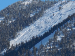
The snowpack in the northern Madison Range requires scrutiny. On Saturday in Bear Basin, skiers triggered a large avalanche on weak snow near the ground (details and photos). It released in a rocky, shallow area of the snowpack and propagated under thicker wind slabs. It is ugly terrain and luckily no one was caught. Triggering a large slide like this is getting more difficult without new snow loading, but still makes my palms sweat.
Dig and look for instability; it only takes a few minutes. A deep slab breaking in a test leaves a strong impression, but conversely, not finding instability is not a green light. Be careful around shallow areas of the snowpack, especially in rocky terrain where facets can be well developed, because these are likely trigger zones. For today avalanches remain possible and the danger is rated MODERATE.

The snowpack in the rest of the forecast area is generally safe with a few isolated issues. A weak layer of faceted snow was buried 8-16” under the snow surface last week, but it is not a widespread problem. Alex found it to be spotty in Hyalite (video), Ian could not get this layer to fracture above Hebgen Lake (video), and near Cooke City they strengthened over the weekend (video). This layer is close to the surface and easy to test.
On Monday, skiers were able to trigger thin wind drifts (6”) in the northern Bridger Range (details, photo). This problem is not widespread, but small avalanches could push us over cliffs or into terrain traps.
Eric skied into the southern Gallatin Range yesterday and found a relatively thin snowpack with sugary facets at the ground (video). In general stability was good and getting better with time. An avalanche on Sunday in Paradise Valley (outside our forecast area) failed in a snowpack that looks similar to this (details, photo). It was skier triggered and broke near the ground wiping out tracks from the day before. Triggering a slide like this is unlikely, but not impossible.
For today, the avalanche danger is rated LOW. Before jumping into steep terrain do a quick stability test since it may reveal one of these isolated problems. If you take your sport seriously, then be serious and dig. People still die during a low avalanche danger.
If you get out and have any avalanche or snowpack observations to share, contact us via our website, email (mtavalanche@gmail.com), phone (406-587-6984), or Instagram (#gnfacobs).
Upcoming Avalanche Education and Events
Our education calendar is full of awareness lectures and field courses. Check it out: Events and Education Calendar.
BOZEMAN
TONIGHT! March 13, Science Inquiry w/ Dr. Karl Birkeland, 7 p.m. at Museum of the Rockies. More info.
Colorado is ground-zero for avalanches. They have 8 avalanche fatalities this season with 3 in the last 10 days. Read the accident reports and let them sink in. No matter your experience level there is always something to learn.