Good morning. This is Doug Chabot with the Gallatin National Forest Avalanche Forecast issued on Thursday, March 14th at 7:00 a.m. Today's forecast is sponsored by Werner Wealth Management and Alpine Orthopedics. This advisory does not apply to operating ski areas.
Yesterday, 6” of snow fell in Hyalite and 1” around Big Sky. Winds are 10-20 mph out of the north except around Bozeman where they are 10-15 mph from the west. This morning skies are cloudy and mountain temperatures are near 10F. By afternoon skies will clear and temperatures will rise above freezing. Clear, sunny weather is the only item on the menu for the next 7 days so stock up on SPF 50 sunscreen.
WET AVALANCHES
Sun and above freezing temperatures makes wet avalanches. If skies clear this afternoon wet loose avalanches will occur on slopes getting direct sunshine.

Yesterday’s storm dropped 6” of snow in Hyalite with north winds blowing 10-20 mph. This is enough to increase the likelihood of triggering slides in the new snow. This snow fell onto ice or wind crusts which will aid in triggering loose avalanches: dry ones in the morning, and wet in the afternoon on sun exposed slopes. Wind drifts near the ridgelines are suspect as well. I do not expect slides to break deeper than the new snow, but these 6+” will be reactive and could push you into a terrain trap. For today, avalanches are possible and the danger is rated MODERATE.
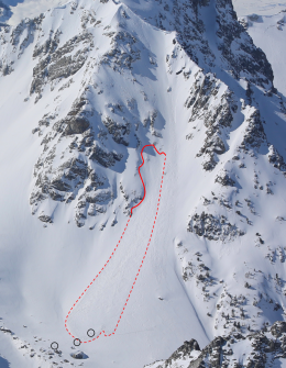
Three skiers on Tuesday triggered a slide near Beehive Peak. It was confined to new, windblown snow and broke 6-8” deep, 100 feet wide and 600 feet vertical (details and photos). On Saturday skiers triggered a similar slide nearby, but it stepped down into deeper snow and created a large avalanche (details and photos). Luckily, this did not happen on Tuesday since all 3 skiers were on the slope at the same time.
Yesterday, I toured into Beehive and Bear Basins and found small facets near the surface (photo) and sugary facets in the bottom of the snowpack (video). This lower layer was not breaking in stability tests, but as the avalanche on Saturday illustrates they are still a player. Given the recent avalanche activity and known weak layers, the avalanche danger is rated MODERATE since avalanches remain possible. Additionally, sun exposed slopes may have wet loose avalanches if skies clear this afternoon.

Without new snow, the Bridger Range, southern Gallatin and southern Madison Ranges, and mountains around Cooke City and West Yellowstone are generally stable. This week Ian was near Hebgen Lake (video), Eric was in the southern Gallatin Range (video) and I was in Cooke City (video). We all found weak layers in the snowpack, some near the ground and others near the surface, but triggering them is unlikely. The weak layer near the surface does not require much digging to test. If the snow propagates in a stability test, reevaluate your travel plan.
For today, the dry snow avalanche danger is rated LOW. Additionally, sun exposed slopes may have wet loose avalanches if skies clear this afternoon.
If you get out and have any avalanche or snowpack observations to share, contact us via our website, email (mtavalanche@gmail.com), phone (406-587-6984), or Instagram (#gnfacobs).
Colorado is ground-zero for avalanches. They have 8 avalanche fatalities this season with 3 in the last 10 days. Read the accident reports and let them sink in. No matter your experience level there is always something to learn.