Good morning. This is Eric Knoff with the Gallatin National Forest Avalanche Forecast issued on Friday, March 15th at 7:00 a.m. Today's forecast is sponsored by Spark R&D and Swiss Fit. This advisory does not apply to operating ski areas.
The Bridger Range picked up 2-3” of snow over the past 24 hours while rest of the forecast area received a trace to 1”. This morning temps are in the single digits to low teens F under partly cloudy skies. Winds are blowing 10-30 mph out of the west-southwest. Today, highs warm into the upper 20’s to low 30’s F and winds will continue to blow 15-30 mph out of the west-southwest. Skies remain partly cloudy today and no snow is expected through the foreseeable future.

On Wednesday, the northern Gallatin Range picked up 6” of low density snow. This quick shot didn’t add a lot of weight to the snowpack, but it did create a few avalanche problems. On many slopes, the new snow rests over a sun crust that formed prior to the storm. This smooth sliding surface will allow dry loose slides to move quickly in steep terrain (photo). Soft slabs will also be a concern on slopes with fresh wind drifted snow. Overnight westerly winds blew upwards of 30 mph at the ridgetops. This likely formed fresh wind slabs on upper elevation slopes. Similar to the dry loose problem, wind drifts will not be exceptionally large but if triggered could be dangerous in higher consequence terrain.
Fresh snow will also increase the potential for wet loose avalanches as the day heats up. Watch for roller balls and small point releases on steep sun exposed slopes. Move to shadier aspects or away from steep terrain if these signs of instability are present.
Dry and wet snow avalanches are possible today. For this reason the avalanche danger is rated MODERATE.

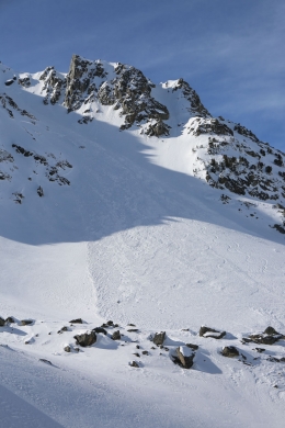
As the days tick by without a loading event, human triggered slab avalanches are becoming less likely but remain possible in isolated areas (video). Yesterday, Ian and I rode into the southern Madison Range and found mostly strong-stable snow, but agreed wind loaded slopes near upper elevation ridgelines and steep rocky terrain will be areas to look out for (video). A slide triggered in Beehive Basin on Tuesday is a reminder of what’s possible today (details and photos).
An additional problem will be wet snow avalanches on steep sun exposed slopes. This problem won’t be widespread, but something to pay attention to on south and west facing slopes during the afternoon hours. Roller balls and point releases are signs the surface snow is becoming unstable. Avoid steep slopes where these signs are present.
Although avalanches are unlikely, they are not impossible. Now is not the time to let your guard down and throw caution the wind. Continue to use safe backcountry protocol and always be thinking about the consequences of a slide.
Today, unstable snow exists on isolated terrain features, but generally safe avalanche conditions exist and the avalanche danger is rated LOW. The wet snow danger could rise to MODERATE on steep sun exposed slopes by this afternoon.
If you get out and have any avalanche or snowpack observations to share, contact us via our website, email (mtavalanche@gmail.com), phone (406-587-6984), or Instagram (#gnfacobs).
Colorado is ground-zero for avalanches. They have 8 avalanche fatalities this season with 3 in the last 10 days. Read the accident reports and let them sink in. No matter your experience level there is always something to learn.