Good morning. This is Alex Marienthal with pre-season avalanche, weather and event information for the Gallatin National Forest Avalanche Center on Friday, December 3rd. This information is sponsored by Blitz Motorsports and Yamaha and OnX maps. We will update this bulletin on Monday, December 6th.
On Monday night the mountains got 3-5” of snow in Hyalite and Big Sky with 1-2” elsewhere. Since Tuesday, temperatures have been generally above freezing reaching 40s and 50s F, and wind has been southwest at 15-25 mph with gusts of 50-60 mph. This morning temperatures are mid-20s to low 30s F and wind is westerly at 10-20 mph. Today temperatures will reach high 30s to low 40s F with westerly wind at 10-20 mph. Wind will increase to 30-40 mph through Saturday and continue through Sunday with gusts of 40-60 mph expected. Saturday night, 1-3” of new snow could fall as temperatures drop to the teens and low 20s F by Sunday morning.

All Regions
The snow that fell on Tuesday was blown into drifts by strong southwest winds. These drifts are the main avalanche hazard today, and most likely exist along ridgelines, below cornices, and on higher elevation slopes where they didn’t melt from the above freezing temperatures. Be cautious of steep, recently wind-loaded slopes which may be tempting to ski or ride because they hold the most snow right now. A few inches of snow on Saturday night with strong wind will create fresh drifts that could be easy to trigger during and immediately after they form.
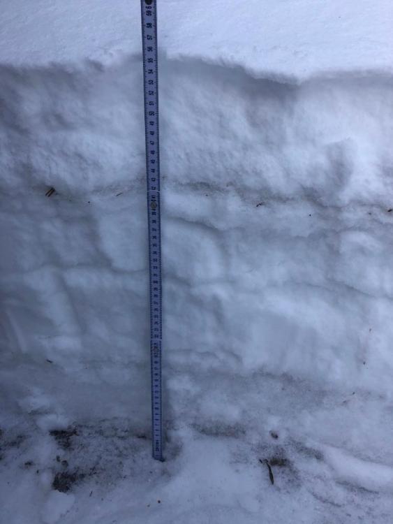
Aside from the above described wind slabs, the snowpack is generally stable after the previous three days of warm, dry weather. However, this recent weather has done no favors for the snowpack in regards to snow depth and future stability. Many low elevation and southerly facing slopes have zero or only a few inches of snow. On higher and shadier slopes the snowpack is 10-20” deep and has layers of crusts and weak faceted snow. We have received reports of these weak layers across the advisory area (Photo 1, photo 2, video from Cooke City) and surrounding mountains (photo of snowpack on Emigrant, photo 2). This weak snow is important to remember because it will probably cause avalanches when we get our next big storm.... maybe next week.
We appreciate the observations you have submitted this season. You are helping us develop a more complete understanding of this season’s snowpack! Please submit observations here. THINK SNOW!
If you have avalanche, snowpack or weather observations to share please submit them via our website, email (mtavalanche@gmail.com), phone (406-587-6984), or Instagram (#gnfacobs).
Upcoming Education Opportunities:
Get your avalanche brain ready for the season at one of the many classes listed on our education calendar, and list of upcoming events below. Don’t delay preparing and inspecting your avalanche gear. Get some tips from Dave Zinn in this Pre-Season gear check video.
December 8, 7-8 pm, Online Free 1 hr Avalanche Awareness in partnership with OnX maps. Link to Join Here.
Our popular Avalanche Fundamentals with Field Course is perfect as a refresher or an introduction to avalanches. We are introducing an exciting new format this year with the four lectures pre-recorded to watch at your convenience, a live question and answer session, and a choice of a snowmobile or ski/ board based field day occurring the following three weekends.
Friends of GNFAC Powder Blast Fund-raiser
The Friends of the Avalanche Center are hosting the Virtual Powder Blast fundraiser. With only $4,000 left to go, help us reach the $65,000 goal. Your donations support free and low-cost avalanche education, beacon checkers at trailheads, beacon parks, weather stations, and GNFAC programs!
Doug was interviewed by Justin Angle for Montana Public Radio about his background, avalanches, and his work in Central Asia. You can listen to the interview HERE.