Good morning. This is Doug Chabot with the Gallatin National Forest Avalanche Forecast on Wednesday, March 16th at 7:15 a.m. This information is sponsored by Grizzly Outfitters and Blitz Motorsports and Yamaha. This forecast does not apply to operating ski areas.
In the last 24 hours the Bridger Range picked up 6” of dense snow while the rest of our forecast area received 3-5”. Wind is blowing westerly at 10-15 mph with gusts of 35 mph under mostly cloudy skies. Mountain temperatures are in the low to mid 20s F. Pulses of snow showers will continue today and drop another inch by this evening. Wind will be 10-20 mph out of the west as temperatures rise into the high 20s this afternoon. Skies will clear tonight.

Chances of triggering an avalanche in the Bridger Range just went up. The 6” of new snow is very dense and heavy and measures .9-1” of snow water equivalent (SWE). One inch of water weight falling in 16 hours is a rapid and heavy load and the snowpack needs time to adjust. The weight of the new snow is causing the elevated danger. There are weak layers of facets in the upper 2 feet of the snowpack that will avalanche under this load. West wind is strong enough to make drifts which could be easily triggered today. Even without a wind load, be on the lookout for shooting cracks or collapses (whumpfs). These are signs of instability. Today’s avalanche danger is elevated to CONSIDERABLE since it’s likely to trigger avalanches.

The mountains around Cooke City received 5” of new snow measuring .5” of SWE. This totals 18+” of new snow since Saturday. Alex spent the last few days there and saw avalanches as recently as Monday. Yesterday he skied around and had an isolated collapse and cracking wind drifts in the trees. A weak layer 1-2 feet under the surface is unstable and could avalanche, especially on slopes with thicker wind drifts. His 2 videos (Saturday, Monday) show the exact nature of the instability that has caused over a dozen slides since Saturday. Triggering avalanches remains possible with the new snow and the danger is rated MODERATE on all slopes.
The mountains south of Bozeman to Big Sky and West Yellowstone received 3-5” of new snow (.3-.5” SWE) and triggering avalanches is a strong possibility. Yesterday Dave investigated a skier triggered avalanche from Sunday in the backcountry outside Big Sky Ski Area (video). A dense slab broke on weak snow that was still showing signs of instability in his test (ECTP 13). Even more impressive than a poor stability test was a large natural avalanche on Cedar Mountain that was witnessed a few hours previous (photo).
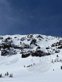
Yesterday, Ian and I skied into Mt Blackmore to look at the skier triggered slide from Monday (video). The snowpack structure is similar throughout southwest Montana: a dense slab of snow is atop a weak layer of facets buried 1-2 feet deep. Every time it snows, even a few inches, this layer becomes unstable on some slopes and folks trigger avalanches. The exact location of these unstable slopes require you to dig and test the snowpack. There’s no easy way to be safe in avalanche terrain without doing homework. Dave found this instability in Beehive on Sunday (“Why We Dig Snowpits” video) and snowmobilers triggered slides on it on Buck Ridge over the weekend (photo). For today, it is possible to trigger avalanches and the danger is rated MODERATE.
If you get out, please send us your observations no matter how brief. You can submit them via our website, email (mtavalanche@gmail.com), phone (406-587-6984), or Instagram (#gnfacobs).
Upcoming Education Opportunities
See our education calendar for an up-to-date list of all local classes. Here are a few select upcoming events.
Read the Montana Free Press article discussing the high number of avalanche fatalities in southwest Montana this winter, featuring an interview with Doug Chabot. The winter of 2021-22 is the deadliest winter in Montana since the 2013-14 season.