Good morning. This is Doug Chabot with the Gallatin National Forest Avalanche Forecast on Thursday, March 17th at 7:00 a.m. This information is sponsored by Bridger Bowl, Cooke City Motorsports and Madison-Gallatin Chapter of Wild Montana. This forecast does not apply to operating ski areas.
Before the storm ended yesterday another 1-3” fell in the mountains, except West Yellowstone. Wind decreased overnight and is averaging 5-15 mph out of the west with gusts of 28 mph (NE at Lionhead). Skies will be mostly sunny today and temperatures will rise from this morning's low of 10-15 F into the mid-30s with light westerly wind. No snow is expected until Sunday.
WET SNOW AVALANCHE DANGER: With today’s mountain temperatures forecasted to be above freezing, shallow, wet loose avalanches may be numerous on slopes getting sunshine.

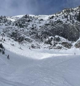
The snowstorm ended yesterday morning and dropped 5-8” of snow equaling .5-1”of snow water equivalent (SWE). On Saddle Peak in the Bridger Range a cornice triggered a slide and a few other natural avalanches were noted (photos and details). Dave skied north of Bridger Bowl and made a video showing wind-loading and weakness under the new snow. For the most part it has bonded to the underlying surface, but not in all cases. Yesterday, a skier triggered and was caught in a small, new snow avalanche above Lava Lake in the northern Madison Range (video).
Yesterday, Ian and his partner rode to Buck Ridge and did not see any avalanches, but they did get an unstable test result in their snowpit (ECTP 22). More importantly, Ian found that after months of waiting for a slab to develop, we finally have one (video). A thick slab of snow on top of a weak layer buried 1-2 feet deep is a recipe for avalanches that will not heal quickly. Although the layering is widespread throughout southwest Montana, the instability is isolated. In the absence of recent avalanches or shooting cracks, the only way to determine stability is to dig and test. On Sunday Dave highlighted this in his Beehive video, which was the same day a skier triggered a 500’ wide slide next to Big Sky Ski Resort (video). Ian and I also noted the sporadic nature of the instability during Tuesday’s tour into Mt. Blackmore (video).
Avalanches are possible today and even small slides can be deadly. In February, a snowmobiler was killed in Lionhead in a slide 75’ wide and yesterday a skier was caught in an avalanche that looked to be 25’ wide. On Saturday, a snowmobiler in southern Wyoming died in a small slide as well (accident investigation video).
Stay clear of wind-loaded terrain at the ridgelines and be prepared to investigate the snowpack. For today the avalanche danger is rated MODERATE on all slopes.
Cooke City has gotten at least 20” of snow since Saturday along with many avalanches (avalanche list). The slides are breaking on a weak layer of facets 1-2 feet under the surface which remains unstable. Alex rode and skied and noted this layer in his two videos from Saturday and Monday. Only expose one person at a time to avalanche terrain and stay away from steep slopes if you get cracking, collapsing or poor test scores. Triggering avalanches remains possible and the danger is rated MODERATE on all slopes.
*Today’s forecast references 8 mtavalanche videos. Instead of clicking on them individually you can watch them all on our 2021-2022 Playlist.
If you get out, please send us your observations no matter how brief. You can submit them via our website, email (mtavalanche@gmail.com), phone (406-587-6984), or Instagram (#gnfacobs).
Read the Montana Free Press article discussing the high number of avalanche fatalities in southwest Montana this winter, featuring an interview with Doug Chabot. The winter of 2021-22 is the deadliest winter in Montana since the 2013-14 season.